Juanacatlán geodata
Juanacatlán (Jalisco) is a seat of a second-order administrative division; located in Mexico in America/Mexico_City (GMT-6) time zone. With population of 9,133 people, there are 1030 cities with bigger population in this country. Compared to other cities in Mexico, 68% of cities are located further ↓South; 86.4% of cities are located further →East and 52.3% of cities have lower elevation than Juanacatlán. Note1


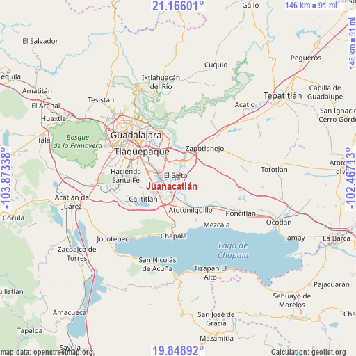
Juanacatlán GPS coordinates[2]
20° 30' 31.968" North, 103° 10' 12.9" West
| Map corner | latitude | longitude |
|---|---|---|
| Upper-left | 21.16601°, | -103.87338° |
| Center: | 20.50888°, | -103.17025° |
| Lower-right: | 19.84892°, | -102.46713° |
| Map W x H: | 146.4×146.4 km | = 91×91mi |
| max Lat: | 32.7° ⇑32% North |
| Juanacatlán: | 20.50888° |
| min Lat: | ⇓68% South 14.53588° |
| min Long | Juanacatlán | max Long |
| -117.105° | -103.17025° | -86.73105° |
| W 13.6%⇐ | ⇒86.4% E |
Elevation
Elevation of Juanacatlán is 1529 m = 5016 ft, and this is 275.3 m = 903 ft above average elevation for this country.
| Max E: |
3497 m = 11473 ft | 47.7% |
| Juanacatlán | 1529 m 5016 ft | |
| Avg. | 1253.7 m = 4113 ft | |
Min E: |
-1 m = -3 ft | 52.3% |
See also: Mexico elevation on elevation.city.
Geographical zone
Juanacatlán is located in North Torrid zone (between Equator and Tropic of Cancer). Distance of this Northern Tropic circle is 325.5 km =202.3 mi to North.| Distance of | km | miles | from Juanacatlán |
|---|---|---|---|
| North Pole | 7726.7 | 4801.1 | to North |
| Arctic Circle | 5120.8 | 3181.9 | to North |
| Tropic Cancer | 325.5 | 202.3 | to North |
| Equator | 2280.4 | 1417 | to South |


Nearby cities:
15 places around Juanacatlán: (largest is in red/bold)
• Agua Escondida
8.8 km =5.5 mi,  87°
87°
• Centro de Readaptación Social
5.6 km =3.5 mi,  334°
334°
• Colonia Guadalupana
8.2 km =5.1 mi,  321°
321°
• El Muey
5.3 km =3.3 mi,  262°
262°
• El Salitre
8.7 km =5.4 mi,  56°
56°
• El Salto
1.6 km =1 mi,  313°
313°
• Galaxia Bonito Jalisco
3.6 km =2.2 mi, 263°
• Hacienda Vieja del Castillo (Castillo Viejo)
8.4 km =5.2 mi,  294°
294°
• La Alameda
8.3 km =5.2 mi, 259°
• La Mezquitera
8.1 km =5 mi,  47°
47°
• La Punta
8.2 km =5.1 mi, 328°
• Paseo Puente Viejo
7 km =4.3 mi,  342°
342°
• Puente Grande
7 km =4.3 mi,  14°
14°
• Rinconada la Loma [Fraccionamiento]
7.9 km =4.9 mi,  219°
219°
• San José del Castillo
7.1 km =4.4 mi,  274°
274°
Sources, notices
• [Note1] Compared only with cities in Mexico existing in our database
• [Src1] Map data: © OpenStreetMap contributors (CC-BY-SA)
• [Src2] Other city data from geonames.org with taken over terms of usage.
• [Src3] Geographical zone / Annual Mean Temperature by Robert A. Rohde @ Wikipedia
