Puente Grande geodata
Puente Grande (Jalisco) is a populated place; located in Mexico in America/Mexico_City (GMT-6) time zone. With population of 5,664 people, there are 1644 cities with bigger population in this country. Compared to other cities in Mexico, 69.4% of cities are located further ↓South; 86.3% of cities are located further →East and 50.8% of cities have lower elevation than Puente Grande. Note1


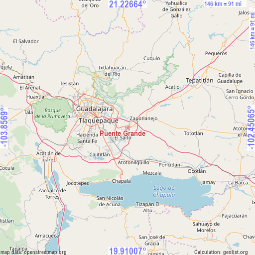
Puente Grande GPS coordinates[2]
20° 34' 11.172" North, 103° 9' 13.572" West
| Map corner | latitude | longitude |
|---|---|---|
| Upper-left | 21.22664°, | -103.8569° |
| Center: | 20.56977°, | -103.15377° |
| Lower-right: | 19.91007°, | -102.45065° |
| Map W x H: | 146.4×146.4 km | = 91×91mi |
| max Lat: | 32.7° ⇑30.6% North |
| Puente Grande: | 20.56977° |
| min Lat: | ⇓69.4% South 14.53588° |
| min Long | Puente Grande | max Long |
| -117.105° | -103.15377° | -86.73105° |
| W 13.7%⇐ | ⇒86.3% E |
Elevation
Elevation of Puente Grande is 1475 m = 4839 ft, and this is 221.3 m = 726 ft above average elevation for this country.
| Max E: |
3497 m = 11473 ft | 49.2% |
| Puente Grande | 1475 m 4839 ft | |
| Avg. | 1253.7 m = 4113 ft | |
Min E: |
-1 m = -3 ft | 50.8% |
See also: Mexico elevation on elevation.city.
Geographical zone
Puente Grande is located in North Torrid zone (between Equator and Tropic of Cancer). Distance of this Northern Tropic circle is 318.8 km =198.1 mi to North.| Distance of | km | miles | from Puente Grande |
|---|---|---|---|
| North Pole | 7719.9 | 4796.9 | to North |
| Arctic Circle | 5114 | 3177.7 | to North |
| Tropic Cancer | 318.8 | 198.1 | to North |
| Equator | 2287.1 | 1421.1 | to South |


Nearby cities:
15 places around Puente Grande: (largest is in red/bold)
• Centro de Readaptación Social
4.5 km =2.8 mi,  247°
247°
• Cerro Santa Fe
8.7 km =5.4 mi,  124°
124°
• Colonia Guadalupana
6.8 km =4.2 mi,  267°
267°
• El Salitre
5.9 km =3.7 mi,  109°
109°
• El Salto
6.3 km =3.9 mi,  207°
207°
• El Vado
4.4 km =2.7 mi,  356°
356°
• Juanacatlán
7 km =4.3 mi,  194°
194°
• La Laja
3.5 km =2.2 mi,  70°
70°
• La Loma
4.2 km =2.6 mi,  77°
77°
• La Mezquitera
4.5 km =2.8 mi, 106°
• La Punta
6 km =3.7 mi, 271°
• Mismaloya (Fraccionamiento Pedregal de Santa Martha)
4.5 km =2.8 mi,  336°
336°
• Paseo Puente Viejo
3.8 km =2.4 mi, 269°
• Paseo de las Cañadas
7.3 km =4.5 mi,  321°
321°
• Pueblos de la Barranca (El Maestranzo)
2.5 km =1.6 mi,  45°
45°
Sources, notices
• [Note1] Compared only with cities in Mexico existing in our database
• [Src1] Map data: © OpenStreetMap contributors (CC-BY-SA)
• [Src2] Other city data from geonames.org with taken over terms of usage.
• [Src3] Geographical zone / Annual Mean Temperature by Robert A. Rohde @ Wikipedia
