Jofre geodata
Jofre (Querétaro) is a populated place; located in Mexico in America/Mexico_City (GMT-6) time zone. With population of 802 people, there are 10884 cities with bigger population in this country. Compared to other cities in Mexico, 74% of cities are located further ↓South; 68.7% of cities are located further →East and 76.3% of cities have lower elevation than Jofre. Note1


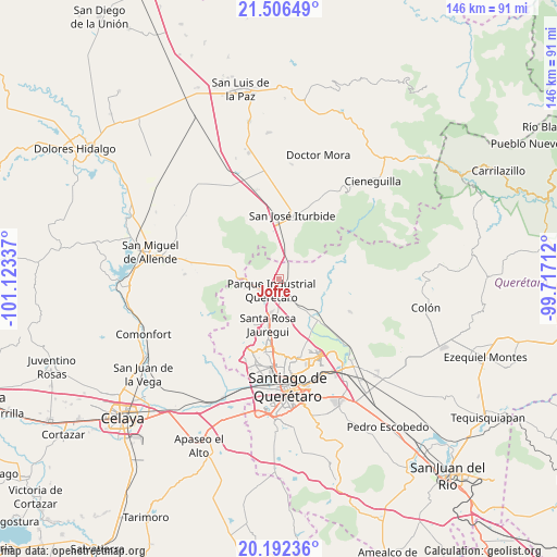
Jofre GPS coordinates[2]
20° 51' 3.096" North, 100° 25' 12.864" West
| Map corner | latitude | longitude |
|---|---|---|
| Upper-left | 21.50649°, | -101.12337° |
| Center: | 20.85086°, | -100.42024° |
| Lower-right: | 20.19236°, | -99.71712° |
| Map W x H: | 146.1×146.1 km | = 90.8×90.8mi |
| max Lat: | 32.7° ⇑26% North |
| Jofre: | 20.85086° |
| min Lat: | ⇓74% South 14.53588° |
| min Long | Jofre | max Long |
| -117.105° | -100.42024° | -86.73105° |
| W 31.3%⇐ | ⇒68.7% E |
Elevation
Elevation of Jofre is 2054 m = 6739 ft, and this is 800.3 m = 2626 ft above average elevation for this country.
| Max E: |
3497 m = 11473 ft | 23.7% |
| Jofre | 2054 m 6739 ft | |
| Avg. | 1253.7 m = 4113 ft | |
Min E: |
-1 m = -3 ft | 76.3% |
See also: Mexico elevation on elevation.city.
Geographical zone
Jofre is located in North Torrid zone (between Equator and Tropic of Cancer). Distance of this Northern Tropic circle is 287.5 km =178.6 mi to North.| Distance of | km | miles | from Jofre |
|---|---|---|---|
| North Pole | 7688.7 | 4777.5 | to North |
| Arctic Circle | 5082.8 | 3158.3 | to North |
| Tropic Cancer | 287.5 | 178.6 | to North |
| Equator | 2318.4 | 1440.6 | to South |


Nearby cities:
15 places around Jofre: (largest is in red/bold)
• Buenavista
6 km =3.7 mi,  239°
239°
• El Pinto
5.4 km =3.4 mi,  169°
169°
• Jofrito
1.2 km =0.7 mi,  6°
6°
• La Estacada
3.5 km =2.2 mi,  158°
158°
• La Gotera
4.8 km =3 mi,  73°
73°
• La Luz
2.7 km =1.7 mi,  316°
316°
• La Palma
4.9 km =3 mi,  38°
38°
• La Versolilla
5 km =3.1 mi,  60°
60°
• Las Lajitas
5.6 km =3.5 mi, 159°
• Medina
5.7 km =3.5 mi,  28°
28°
• Ojo de Agua
3.8 km =2.4 mi, 9°
• Palo Alto
2.8 km =1.7 mi,  50°
50°
• Pintillo
6 km =3.7 mi,  176°
176°
• Puerto de Aguirre
5.1 km =3.2 mi,  194°
194°
• Puerto de Carroza
5.4 km =3.4 mi, 9°
Sources, notices
• [Note1] Compared only with cities in Mexico existing in our database
• [Src1] Map data: © OpenStreetMap contributors (CC-BY-SA)
• [Src2] Other city data from geonames.org with taken over terms of usage.
• [Src3] Geographical zone / Annual Mean Temperature by Robert A. Rohde @ Wikipedia
