Pintillo geodata
Pintillo (Querétaro) is a populated place; located in Mexico in America/Mexico_City (GMT-6) time zone. With population of 1,035 people, there are 8423 cities with bigger population in this country. Compared to other cities in Mexico, 73.3% of cities are located further ↓South; 68.7% of cities are located further →East and 74.6% of cities have lower elevation than Pintillo. Note1


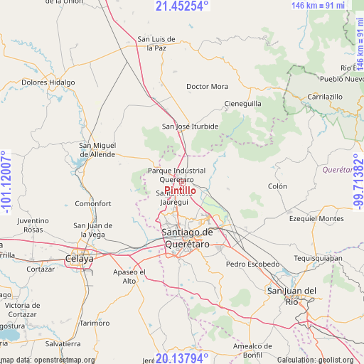
Pintillo GPS coordinates[2]
20° 47' 48.012" North, 100° 25' 0.984" West
| Map corner | latitude | longitude |
|---|---|---|
| Upper-left | 21.45254°, | -101.12007° |
| Center: | 20.79667°, | -100.41694° |
| Lower-right: | 20.13794°, | -99.71382° |
| Map W x H: | 146.2×146.2 km | = 90.8×90.8mi |
| max Lat: | 32.7° ⇑26.7% North |
| Pintillo: | 20.79667° |
| min Lat: | ⇓73.3% South 14.53588° |
| min Long | Pintillo | max Long |
| -117.105° | -100.41694° | -86.73105° |
| W 31.3%⇐ | ⇒68.7% E |
Elevation
Elevation of Pintillo is 2023 m = 6637 ft, and this is 769.3 m = 2524 ft above average elevation for this country.
| Max E: |
3497 m = 11473 ft | 25.4% |
| Pintillo | 2023 m 6637 ft | |
| Avg. | 1253.7 m = 4113 ft | |
Min E: |
-1 m = -3 ft | 74.6% |
See also: Mexico elevation on elevation.city.
Geographical zone
Pintillo is located in North Torrid zone (between Equator and Tropic of Cancer). Distance of this Northern Tropic circle is 293.5 km =182.4 mi to North.| Distance of | km | miles | from Pintillo |
|---|---|---|---|
| North Pole | 7694.7 | 4781.3 | to North |
| Arctic Circle | 5088.8 | 3162 | to North |
| Tropic Cancer | 293.5 | 182.4 | to North |
| Equator | 2312.4 | 1436.9 | to South |


Nearby cities:
15 places around Pintillo: (largest is in red/bold)
• Buenavista
6.3 km =3.9 mi,  298°
298°
• Corea
3.5 km =2.2 mi,  279°
279°
• El Pinto
0.9 km =0.6 mi,  42°
42°
• Hacienda Santa Rosa [Fraccionamiento]
4 km =2.5 mi,  213°
213°
• Jofre
6 km =3.7 mi,  356°
356°
• La Estacada
2.9 km =1.8 mi,  19°
19°
• La Solana
6.9 km =4.3 mi,  160°
160°
• Las Lajitas
1.8 km =1.1 mi,  64°
64°
• Montenegro
3.9 km =2.4 mi,  198°
198°
• Puerto de Aguirre
1.9 km =1.2 mi, 304°
• San Isidro Buenavista
3.5 km =2.2 mi,  255°
255°
• San José Buenavista
6.9 km =4.3 mi,  173°
173°
• Santa Catarina
4.3 km =2.7 mi,  238°
238°
• Santa Rosa Jauregui
7 km =4.3 mi, 207°
• Tierra Blanca
4.3 km =2.7 mi,  115°
115°
Sources, notices
• [Note1] Compared only with cities in Mexico existing in our database
• [Src1] Map data: © OpenStreetMap contributors (CC-BY-SA)
• [Src2] Other city data from geonames.org with taken over terms of usage.
• [Src3] Geographical zone / Annual Mean Temperature by Robert A. Rohde @ Wikipedia
