Buenavista geodata
Buenavista (Querétaro) is a populated place; located in Mexico in America/Mexico_City (GMT-6) time zone. With population of 4,115 people, there are 2225 cities with bigger population in this country. Compared to other cities in Mexico, 73.7% of cities are located further ↓South; 69.2% of cities are located further →East and 74.9% of cities have lower elevation than Buenavista. Note1


Buenavista GPS coordinates[2]
20° 49' 25.392" North, 100° 28' 12.324" West
| Map corner | latitude | longitude |
|---|---|---|
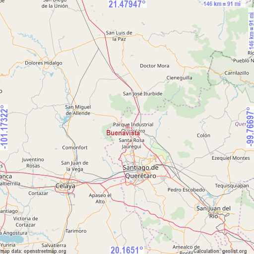
| Upper-left | 21.47947°, | -101.17322° |
| Center: | 20.82372°, | -100.47009° |
| Lower-right: | 20.1651°, | -99.76697° |
| Map W x H: | 146.1×146.1 km | = 90.8×90.8mi |
| max Lat: | 32.7° ⇑26.3% North |
| Buenavista: | 20.82372° |
| min Lat: | ⇓73.7% South 14.53588° |
| min Long | Buenavista | max Long |
| -117.105° | -100.47009° | -86.73105° |
| W 30.8%⇐ | ⇒69.2% E |
Elevation
Elevation of Buenavista is 2029 m = 6657 ft, and this is 775.3 m = 2544 ft above average elevation for this country.
| Max E: |
3497 m = 11473 ft | 25.1% |
| Buenavista | 2029 m 6657 ft | |
| Avg. | 1253.7 m = 4113 ft | |
Min E: |
-1 m = -3 ft | 74.9% |
See also: Mexico elevation on elevation.city.
Geographical zone
Buenavista is located in North Torrid zone (between Equator and Tropic of Cancer). Distance of this Northern Tropic circle is 290.5 km =180.5 mi to North.| Distance of | km | miles | from Buenavista |
|---|---|---|---|
| North Pole | 7691.7 | 4779.4 | to North |
| Arctic Circle | 5085.8 | 3160.2 | to North |
| Tropic Cancer | 290.5 | 180.5 | to North |
| Equator | 2315.4 | 1438.7 | to South |


Nearby cities:
15 places around Buenavista: (largest is in red/bold)
• Cerro de la Cruz
3.4 km =2.1 mi,  252°
252°
• Corea
3.2 km =2 mi,  139°
139°
• El Pinto
6.6 km =4.1 mi,  110°
110°
• Jofre
6 km =3.7 mi,  59°
59°
• Jofrito
6.8 km =4.2 mi,  51°
51°
• La Barreta
3.8 km =2.4 mi,  277°
277°
• La Carbonera
4.1 km =2.5 mi,  240°
240°
• La Estacada
6.5 km =4 mi,  92°
92°
• La Luz
6 km =3.7 mi,  33°
33°
• La Monja
3.6 km =2.2 mi,  306°
306°
• Pie de Gallo
5 km =3.1 mi,  207°
207°
• Pintillo
6.3 km =3.9 mi,  118°
118°
• Puerto de Aguirre
4.4 km =2.7 mi, 115°
• San Isidro Buenavista
4.5 km =2.8 mi,  150°
150°
• Santa Catarina
5.5 km =3.4 mi,  160°
160°
Sources, notices
• [Note1] Compared only with cities in Mexico existing in our database
• [Src1] Map data: © OpenStreetMap contributors (CC-BY-SA)
• [Src2] Other city data from geonames.org with taken over terms of usage.
• [Src3] Geographical zone / Annual Mean Temperature by Robert A. Rohde @ Wikipedia
