Ixtapa geodata
Ixtapa (Jalisco) is a populated place; located in Mexico in America/Mexico_City (GMT-6) time zone. With population of 29,036 people, there are 345 cities with bigger population in this country. Compared to other cities in Mexico, 72% of cities are located further ↓South; 92.4% of cities are located further →East and 89.4% of cities have higher elevation than Ixtapa. Note1


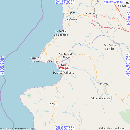
Ixtapa GPS coordinates[2]
20° 42' 59.076" North, 105° 12' 17.532" West
| Map corner | latitude | longitude |
|---|---|---|
| Upper-left | 21.37263°, | -105.908° |
| Center: | 20.71641°, | -105.20487° |
| Lower-right: | 20.05733°, | -104.50175° |
| Map W x H: | 146.2×146.3 km | = 90.8×90.9mi |
| max Lat: | 32.7° ⇑28% North |
| Ixtapa: | 20.71641° |
| min Lat: | ⇓72% South 14.53588° |
| min Long | Ixtapa | max Long |
| -117.105° | -105.20487° | -86.73105° |
| W 7.6%⇐ | ⇒92.4% E |
Elevation
Elevation of Ixtapa is 26 m = 85 ft, and this is 1227.7 m = 4028 ft below average elevation for this country.
| Max E: |
3497 m = 11473 ft | 89.4% |
| Avg. | 1253.7 m = 4113 ft | |
| Ixtapa | 26 m = 85 ft | |
Min E: |
-1 m = -3 ft | 10.6% |
See also: Mexico elevation on elevation.city.
Geographical zone
Ixtapa is located in North Torrid zone (between Equator and Tropic of Cancer). Distance of this Northern Tropic circle is 302.5 km =188 mi to North.| Distance of | km | miles | from Ixtapa |
|---|---|---|---|
| North Pole | 7703.6 | 4786.8 | to North |
| Arctic Circle | 5097.7 | 3167.6 | to North |
| Tropic Cancer | 302.5 | 188 | to North |
| Equator | 2303.4 | 1431.3 | to South |


Nearby cities:
15 places around Ixtapa: (largest is in red/bold)
• Banus Vallarta (Verde Vallarta)
1.9 km =1.2 mi,  268°
268°
• El Colorado
7.8 km =4.8 mi,  40°
40°
• El Porvenir
5.7 km =3.5 mi,  317°
317°
• El Ranchito
6.1 km =3.8 mi,  71°
71°
• El Zancudo
8.8 km =5.5 mi, 37°
• La Desembocada
5.3 km =3.3 mi, 74°
• Las Jarretaderas
7.7 km =4.8 mi,  249°
249°
• Las Juntas
4.6 km =2.9 mi, 248°
• Mezcales
8.2 km =5.1 mi,  281°
281°
• Mezcalitos
8.1 km =5 mi, 267°
• Nuevo Vallarta
9.4 km =5.8 mi,  260°
260°
• San Clemente de Lima
7.2 km =4.5 mi,  288°
288°
• San José del Valle
5.8 km =3.6 mi,  335°
335°
• San Vicente
5.9 km =3.7 mi,  307°
307°
• Tondoroque
9.9 km =6.2 mi, 289°
Sources, notices
• [Note1] Compared only with cities in Mexico existing in our database
• [Src1] Map data: © OpenStreetMap contributors (CC-BY-SA)
• [Src2] Other city data from geonames.org with taken over terms of usage.
• [Src3] Geographical zone / Annual Mean Temperature by Robert A. Rohde @ Wikipedia
