San Clemente de Lima geodata
San Clemente de Lima (Nayarit) is a populated place; located in Mexico in America/Bahia_Banderas (GMT-6) time zone. With population of 1,021 people, there are 8525 cities with bigger population in this country. Compared to other cities in Mexico, 72.3% of cities are located further ↓South; 92.6% of cities are located further →East and 95.1% of cities have higher elevation than San Clemente de Lima. Note1
Current local time in San Clemente de Lima:
06:53 AM, WednesdayDifference from your time zone: hours


San Clemente de Lima GPS coordinates[2]
20° 44' 13.992" North, 105° 16' 14.988" West
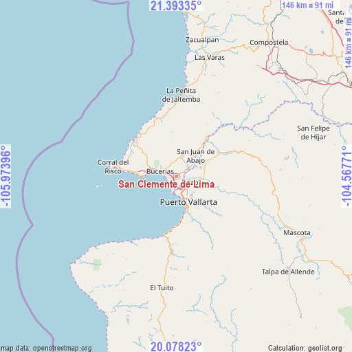
| Map corner | latitude | longitude |
|---|---|---|
| Upper-left | 21.39335°, | -105.97396° |
| Center: | 20.73722°, | -105.27083° |
| Lower-right: | 20.07823°, | -104.56771° |
| Map W x H: | 146.2×146.2 km | = 90.8×90.8mi |
| max Lat: | 32.7° ⇑27.7% North |
| San Clemente de Lima: | 20.73722° |
| min Lat: | ⇓72.3% South 14.53588° |
| min Long | San Clemente de | max Long |
| -117.105° | -105.27083° | -86.73105° |
| W 7.4%⇐ | ⇒92.6% E |
Elevation
Elevation of San Clemente de Lima is 13 m = 43 ft, and this is 1240.7 m = 4071 ft below average elevation for this country.
| Max E: |
3497 m = 11473 ft | 95.1% |
| Avg. | 1253.7 m = 4113 ft | |
| San Clemente de Lima | 13 m = 43 ft | |
Min E: |
-1 m = -3 ft | 4.9% |
See also: Mexico elevation on elevation.city.
Geographical zone
San Clemente de Lima is located in North Torrid zone (between Equator and Tropic of Cancer). Distance of this Northern Tropic circle is 300.2 km =186.5 mi to North.| Distance of | km | miles | from San Clemente de Lima |
|---|---|---|---|
| North Pole | 7701.3 | 4785.4 | to North |
| Arctic Circle | 5095.4 | 3166.1 | to North |
| Tropic Cancer | 300.2 | 186.5 | to North |
| Equator | 2305.8 | 1432.8 | to South |


Nearby cities:
15 places around San Clemente de Lima: (largest is in red/bold)
• Banus Vallarta (Verde Vallarta)
5.5 km =3.4 mi,  115°
115°
• Bucerías
6.9 km =4.3 mi,  287°
287°
• Cruz de Huanacaxtle
11.2 km =7 mi,  279°
279°
• El Porvenir
3.5 km =2.2 mi,  58°
58°
• Ixtapa
7.2 km =4.5 mi,  108°
108°
• Las Jarretaderas
5 km =3.1 mi,  183°
183°
• Las Juntas
4.8 km =3 mi,  146°
146°
• Mezcales
1.4 km =0.9 mi,  239°
239°
• Mezcalitos
2.9 km =1.8 mi,  203°
203°
• Nuevo Vallarta
4.6 km =2.9 mi,  211°
211°
• San José del Valle
5.3 km =3.3 mi, 56°
• San Juan de Abajo
11.9 km =7.4 mi,  43°
43°
• San Vicente
2.5 km =1.6 mi, 59°
• Tondoroque
2.6 km =1.6 mi, 290°
• Valle de Banderas
8.2 km =5.1 mi,  16°
16°
Sources, notices
• [Note1] Compared only with cities in Mexico existing in our database
• [Src1] Map data: © OpenStreetMap contributors (CC-BY-SA)
• [Src2] Other city data from geonames.org with taken over terms of usage.
• [Src3] Geographical zone / Annual Mean Temperature by Robert A. Rohde @ Wikipedia
