El Porvenir geodata
El Porvenir (Jalisco) is a populated place; located in Mexico in America/Mazatlan (GMT-7) time zone. With population of 6,046 people, there are 1549 cities with bigger population in this country. Compared to other cities in Mexico, 72.6% of cities are located further ↓South; 92.5% of cities are located further →East and 90.4% of cities have higher elevation than El Porvenir. Note1


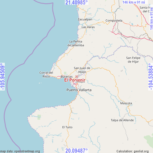
El Porvenir GPS coordinates[2]
20° 45' 13.644" North, 105° 14' 31.056" West
| Map corner | latitude | longitude |
|---|---|---|
| Upper-left | 21.40985°, | -105.94509° |
| Center: | 20.75379°, | -105.24196° |
| Lower-right: | 20.09487°, | -104.53884° |
| Map W x H: | 146.2×146.2 km | = 90.8×90.8mi |
| max Lat: | 32.7° ⇑27.4% North |
| El Porvenir: | 20.75379° |
| min Lat: | ⇓72.6% South 14.53588° |
| min Long | El Porvenir | max Long |
| -117.105° | -105.24196° | -86.73105° |
| W 7.5%⇐ | ⇒92.5% E |
Elevation
Elevation of El Porvenir is 23 m = 75 ft, and this is 1230.7 m = 4038 ft below average elevation for this country.
| Max E: |
3497 m = 11473 ft | 90.4% |
| Avg. | 1253.7 m = 4113 ft | |
| El Porvenir | 23 m = 75 ft | |
Min E: |
-1 m = -3 ft | 9.6% |
See also: Mexico elevation on elevation.city.
Geographical zone
El Porvenir is located in North Torrid zone (between Equator and Tropic of Cancer). Distance of this Northern Tropic circle is 298.3 km =185.4 mi to North.| Distance of | km | miles | from El Porvenir |
|---|---|---|---|
| North Pole | 7699.5 | 4784.2 | to North |
| Arctic Circle | 5093.6 | 3165 | to North |
| Tropic Cancer | 298.3 | 185.4 | to North |
| Equator | 2307.6 | 1433.9 | to South |


Nearby cities:
15 places around El Porvenir: (largest is in red/bold)
• Banus Vallarta (Verde Vallarta)
4.6 km =2.9 mi,  154°
154°
• El Colorado
9.1 km =5.7 mi,  78°
78°
• Ixtapa
5.7 km =3.5 mi,  137°
137°
• La Desembocada
9.4 km =5.8 mi,  106°
106°
• Las Jarretaderas
7.6 km =4.7 mi,  205°
205°
• Las Juntas
5.8 km =3.6 mi,  183°
183°
• Mezcales
4.9 km =3 mi,  238°
238°
• Mezcalitos
6.2 km =3.9 mi,  222°
222°
• Nuevo Vallarta
7.9 km =4.9 mi, 223°
• San Clemente de Lima
3.5 km =2.2 mi, 238°
• San José del Valle
1.8 km =1.1 mi,  52°
52°
• San Juan de Abajo
8.6 km =5.3 mi,  37°
37°
• San Vicente
1 km =0.6 mi, 236°
• Tondoroque
5.5 km =3.4 mi,  260°
260°
• Valle de Banderas
6.1 km =3.8 mi,  353°
353°
Sources, notices
• [Note1] Compared only with cities in Mexico existing in our database
• [Src1] Map data: © OpenStreetMap contributors (CC-BY-SA)
• [Src2] Other city data from geonames.org with taken over terms of usage.
• [Src3] Geographical zone / Annual Mean Temperature by Robert A. Rohde @ Wikipedia
