Iraguato geodata
Iraguato (Sinaloa) is a populated place; located in Mexico in America/Mazatlan (GMT-7) time zone. With population of 535 people, there are 15842 cities with bigger population in this country. Compared to other cities in Mexico, 91.1% of cities are located further ↓South; 95.2% of cities are located further →East and 98.1% of cities have higher elevation than Iraguato. Note1


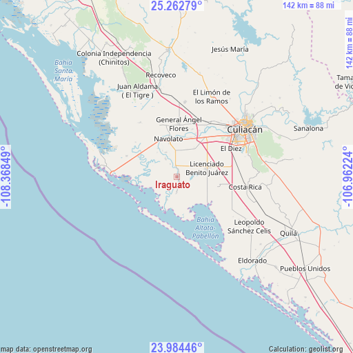
Iraguato GPS coordinates[2]
24° 37' 30.936" North, 107° 39' 55.296" West
| Map corner | latitude | longitude |
|---|---|---|
| Upper-left | 25.26279°, | -108.36849° |
| Center: | 24.62526°, | -107.66536° |
| Lower-right: | 23.98446°, | -106.96224° |
| Map W x H: | 142.1×142.1 km | = 88.3×88.3mi |
| max Lat: | 32.7° ⇑8.9% North |
| Iraguato: | 24.62526° |
| min Lat: | ⇓91.1% South 14.53588° |
| min Long | Iraguato | max Long |
| -117.105° | -107.66536° | -86.73105° |
| W 4.8%⇐ | ⇒95.2% E |
Elevation
Elevation of Iraguato is 8 m = 26 ft, and this is 1245.7 m = 4087 ft below average elevation for this country.
| Max E: |
3497 m = 11473 ft | 98.1% |
| Avg. | 1253.7 m = 4113 ft | |
| Iraguato | 8 m = 26 ft | |
Min E: |
-1 m = -3 ft | 1.9% |
See also: Mexico elevation on elevation.city.
Geographical zone
Iraguato is located in North temperate zone (between Tropic of Cancer and the Arctic Circle). Distance of this Northern Tropic circle is 132.2 km =82.1 mi to South.| Distance of | km | miles | from Iraguato |
|---|---|---|---|
| North Pole | 7269 | 4516.7 | to North |
| Arctic Circle | 4663.1 | 2897.5 | to North |
| Tropic Cancer | 132.2 | 82.1 | to South |
| Equator | 2738.1 | 1701.4 | to South |


Nearby cities:
15 places around Iraguato: (largest is in red/bold)
• Aguapepito
3.6 km =2.2 mi,  195°
195°
• Colonia Michoacana
11.6 km =7.2 mi,  16°
16°
• Colonia Michoacana (Luis Vélez)
7.2 km =4.5 mi,  50°
50°
• El Castillo
9.9 km =6.2 mi, 203°
• El Molino
6 km =3.7 mi,  179°
179°
• El Potrero de Sataya
8.5 km =5.3 mi,  328°
328°
• La Curva (La Curva de San Pedro)
13.2 km =8.2 mi,  31°
31°
• La Vuelta
10.8 km =6.7 mi,  337°
337°
• Las Trancas
12.7 km =7.9 mi,  321°
321°
• Licenciado Benito Juárez (Campo Gobierno)
12.7 km =7.9 mi,  73°
73°
• Lo de Jesús (Campo Romero)
13.6 km =8.5 mi,  63°
63°
• Rosa Morada
5.9 km =3.7 mi, 333°
• Sataya
1 km =0.6 mi, 73°
• Villa Juárez
13.1 km =8.1 mi, 73°
• Villamoros
4.5 km =2.8 mi,  352°
352°
Sources, notices
• [Note1] Compared only with cities in Mexico existing in our database
• [Src1] Map data: © OpenStreetMap contributors (CC-BY-SA)
• [Src2] Other city data from geonames.org with taken over terms of usage.
• [Src3] Geographical zone / Annual Mean Temperature by Robert A. Rohde @ Wikipedia
