Guanajuato geodata
Guanajuato is a seat of a first-order administrative division; located in Mexico in America/Mexico_City (GMT-6) time zone. With population of 72,237 people, there are 167 cities with bigger population in this country. Compared to other cities in Mexico, 76.7% of cities are located further ↓South; 75.3% of cities are located further →East and 73.9% of cities have lower elevation than Guanajuato. Note1


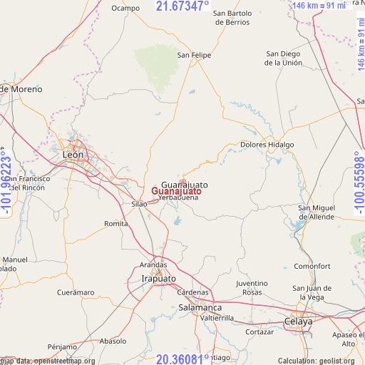
Guanajuato GPS coordinates[2]
21° 1' 6.888" North, 101° 15' 32.76" West
| Map corner | latitude | longitude |
|---|---|---|
| Upper-left | 21.67347°, | -101.96223° |
| Center: | 21.01858°, | -101.2591° |
| Lower-right: | 20.36081°, | -100.55598° |
| Map W x H: | 146×146 km | = 90.7×90.7mi |
| max Lat: | 32.7° ⇑23.3% North |
| Guanajuato: | 21.01858° |
| min Lat: | ⇓76.7% South 14.53588° |
| min Long | Guanajuato | max Long |
| -117.105° | -101.2591° | -86.73105° |
| W 24.7%⇐ | ⇒75.3% E |
Elevation
Elevation of Guanajuato is 2010 m = 6594 ft, and this is 756.3 m = 2481 ft above average elevation for this country.
| Max E: |
3497 m = 11473 ft | 26.1% |
| Guanajuato | 2010 m 6594 ft | |
| Avg. | 1253.7 m = 4113 ft | |
Min E: |
-1 m = -3 ft | 73.9% |
See also: Guanajuato elevation on elevation.city.
Geographical zone
Guanajuato is located in North Torrid zone (between Equator and Tropic of Cancer). Distance of this Northern Tropic circle is 268.9 km =167.1 mi to North.| Distance of | km | miles | from Guanajuato |
|---|---|---|---|
| North Pole | 7670 | 4765.9 | to North |
| Arctic Circle | 5064.1 | 3146.7 | to North |
| Tropic Cancer | 268.9 | 167.1 | to North |
| Equator | 2337 | 1452.1 | to South |


Nearby cities:
15 places around Guanajuato: (largest is in red/bold)
• Calderones
4.7 km =2.9 mi,  132°
132°
• El Maluco
9.7 km =6 mi,  198°
198°
• Fraccionamiento Arboledas
7.3 km =4.5 mi, 196°
• Fraccionamiento Villas de Guanajuato
7.6 km =4.7 mi,  211°
211°
• La Concepción
8.3 km =5.2 mi,  6°
6°
• Marfil
4 km =2.5 mi,  221°
221°
• Mineral de la Luz
9.7 km =6 mi,  301°
301°
• Paso de Pirules
8.7 km =5.4 mi, 209°
• Puentecillas
9.9 km =6.2 mi,  191°
191°
• San Isidro
7.4 km =4.6 mi, 189°
• San José de Cervera
7.2 km =4.5 mi, 218°
• Santa Ana (Santana)
3.6 km =2.2 mi,  338°
338°
• Santa Rosa de Lima
8.7 km =5.4 mi,  47°
47°
• Santa Teresa
8.8 km =5.5 mi, 222°
• Yerbabuena
6.4 km =4 mi, 194°
Sources, notices
• [Note1] Compared only with cities in Mexico existing in our database
• [Src1] Map data: © OpenStreetMap contributors (CC-BY-SA)
• [Src2] Other city data from geonames.org with taken over terms of usage.
• [Src3] Geographical zone / Annual Mean Temperature by Robert A. Rohde @ Wikipedia
