El Venado geodata
El Venado (Nayarit) is a populated place; located in Mexico in America/Mazatlan (GMT-7) time zone. With population of 1,367 people, there are 6353 cities with bigger population in this country. Compared to other cities in Mexico, 83.8% of cities are located further ↓South; 91.9% of cities are located further →East and 83% of cities have higher elevation than El Venado. Note1


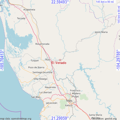
El Venado GPS coordinates[2]
21° 56' 39.336" North, 105° 0' 3.6" West
| Map corner | latitude | longitude |
|---|---|---|
| Upper-left | 22.59493°, | -105.70413° |
| Center: | 21.94426°, | -105.001° |
| Lower-right: | 21.29059°, | -104.29788° |
| Map W x H: | 145×145 km | = 90.1×90.1mi |
| max Lat: | 32.7° ⇑16.2% North |
| El Venado: | 21.94426° |
| min Lat: | ⇓83.8% South 14.53588° |
| min Long | El Venado | max Long |
| -117.105° | -105.001° | -86.73105° |
| W 8.1%⇐ | ⇒91.9% E |
Elevation
Elevation of El Venado is 60 m = 197 ft, and this is 1193.7 m = 3916 ft below average elevation for this country.
| Max E: |
3497 m = 11473 ft | 83% |
| Avg. | 1253.7 m = 4113 ft | |
| El Venado | 60 m = 197 ft | |
Min E: |
-1 m = -3 ft | 17% |
See also: Mexico elevation on elevation.city.
Geographical zone
El Venado is located in North Torrid zone (between Equator and Tropic of Cancer). Distance of this Northern Tropic circle is 165.9 km =103.1 mi to North.| Distance of | km | miles | from El Venado |
|---|---|---|---|
| North Pole | 7567.1 | 4702 | to North |
| Arctic Circle | 4961.2 | 3082.7 | to North |
| Tropic Cancer | 165.9 | 103.1 | to North |
| Equator | 2440 | 1516.1 | to South |


Nearby cities:
15 places around El Venado: (largest is in red/bold)
• Cofradía de Cuyutlán
17 km =10.6 mi,  316°
316°
• El Capomal
17 km =10.6 mi,  226°
226°
• El Tizate
19.8 km =12.3 mi,  217°
217°
• El Vado de San Pedro
18.5 km =11.5 mi,  271°
271°
• Estación Nanchi (Peñasquillo)
17.4 km =10.8 mi,  202°
202°
• Heroico Batallón de San Blas
17.2 km =10.7 mi,  255°
255°
• Las Pilas
19.5 km =12.1 mi,  300°
300°
• Mojocuautla (Adjuntas)
16 km =9.9 mi,  345°
345°
• Presidio de los Reyes
12.9 km =8 mi,  36°
36°
• Ruíz
14.7 km =9.1 mi, 272°
• San Lorenzo
8.1 km =5 mi, 267°
• San Pedro Ixcatan
12.7 km =7.9 mi,  33°
33°
• Santa Fe
12.6 km =7.8 mi, 323°
• Valle Lerma
18.1 km =11.2 mi, 215°
• Yago
13.7 km =8.5 mi,  208°
208°
Sources, notices
• [Note1] Compared only with cities in Mexico existing in our database
• [Src1] Map data: © OpenStreetMap contributors (CC-BY-SA)
• [Src2] Other city data from geonames.org with taken over terms of usage.
• [Src3] Geographical zone / Annual Mean Temperature by Robert A. Rohde @ Wikipedia
