Estación Nanchi (Peñasquillo) geodata
Estación Nanchi (Peñasquillo) (Nayarit) is a populated place; located in Mexico in America/Mazatlan (GMT-7) time zone. With population of 741 people, there are 11804 cities with bigger population in this country. Compared to other cities in Mexico, 82.9% of cities are located further ↓South; 92% of cities are located further →East and 86.5% of cities have higher elevation than Estación Nanchi (Peñasquillo). Note1
Current local time in Estación Nanchi (Peñasquillo):
07:33 AM, WednesdayDifference from your time zone: hours


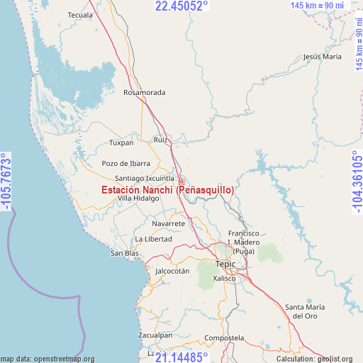
Estación Nanchi (Peñasquillo) GPS coordinates[2]
21° 47' 57.012" North, 105° 3' 51.012" West
| Map corner | latitude | longitude |
|---|---|---|
| Upper-left | 22.45052°, | -105.7673° |
| Center: | 21.79917°, | -105.06417° |
| Lower-right: | 21.14485°, | -104.36105° |
| Map W x H: | 145.2×145.2 km | = 90.2×90.2mi |
| max Lat: | 32.7° ⇑17.1% North |
| Estación Nanchi (Peñasquillo): | 21.79917° |
| min Lat: | ⇓82.9% South 14.53588° |
| min Long | Estación Nanch | max Long |
| -117.105° | -105.06417° | -86.73105° |
| W 8%⇐ | ⇒92% E |
Elevation
Elevation of Estación Nanchi (Peñasquillo) is 36 m = 118 ft, and this is 1217.7 m = 3995 ft below average elevation for this country.
| Max E: |
3497 m = 11473 ft | 86.5% |
| Avg. | 1253.7 m = 4113 ft | |
| Estación Nanchi (Peñasquillo) | 36 m = 118 ft | |
Min E: |
-1 m = -3 ft | 13.5% |
See also: Mexico elevation on elevation.city.
Geographical zone
Estación Nanchi (Peñasquillo) is located in North Torrid zone (between Equator and Tropic of Cancer). Distance of this Northern Tropic circle is 182.1 km =113.2 mi to North.| Distance of | km | miles | from Estación Nanchi (Peñasquillo) |
|---|---|---|---|
| North Pole | 7583.2 | 4712 | to North |
| Arctic Circle | 4977.3 | 3092.7 | to North |
| Tropic Cancer | 182.1 | 113.2 | to North |
| Equator | 2423.8 | 1506.1 | to South |


Nearby cities:
15 places around Estación Nanchi (Peñasquillo): (largest is in red/bold)
• Cinco de Mayo
12.3 km =7.6 mi,  191°
191°
• El Capomal
7.4 km =4.6 mi,  307°
307°
• El Jicote
8.2 km =5.1 mi,  175°
175°
• El Tambor
6.5 km =4 mi,  152°
152°
• El Tizate
5.4 km =3.4 mi,  273°
273°
• Heroico Batallón de San Blas
15.6 km =9.7 mi,  319°
319°
• La Presa
14.2 km =8.8 mi, 270°
• Leandro B. Flores
11.5 km =7.1 mi,  256°
256°
• Mojarritas
5.1 km =3.2 mi, 175°
• Puerta Azul
11.5 km =7.1 mi,  287°
287°
• Santiago Ixcuintla
15 km =9.3 mi,  275°
275°
• Sauta
11.9 km =7.4 mi,  222°
222°
• Vado del Cora (Estación Pani)
9.2 km =5.7 mi,  139°
139°
• Valle Lerma
4.3 km =2.7 mi, 289°
• Yago
4.1 km =2.5 mi,  359°
359°
Sources, notices
• [Note1] Compared only with cities in Mexico existing in our database
• [Src1] Map data: © OpenStreetMap contributors (CC-BY-SA)
• [Src2] Other city data from geonames.org with taken over terms of usage.
• [Src3] Geographical zone / Annual Mean Temperature by Robert A. Rohde @ Wikipedia
