Ruíz geodata
Ruíz (Nayarit) is a seat of a second-order administrative division; located in Mexico in America/Mazatlan (GMT-7) time zone. With population of 14,050 people, there are 690 cities with bigger population in this country. Compared to other cities in Mexico, 83.8% of cities are located further ↓South; 92.1% of cities are located further →East and 87.2% of cities have higher elevation than Ruíz. Note1


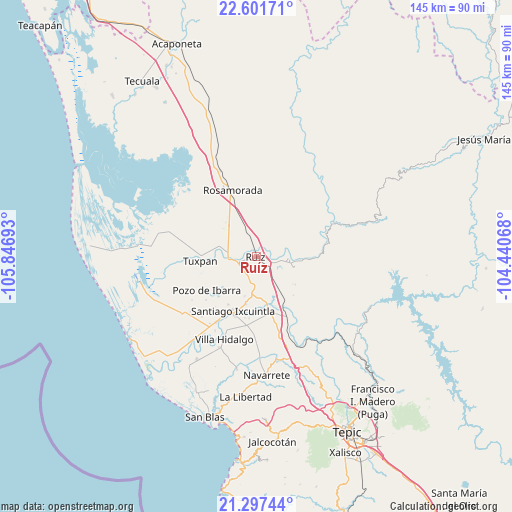
Ruíz GPS coordinates[2]
21° 57' 3.852" North, 105° 8' 37.68" West
| Map corner | latitude | longitude |
|---|---|---|
| Upper-left | 22.60171°, | -105.84693° |
| Center: | 21.95107°, | -105.1438° |
| Lower-right: | 21.29744°, | -104.44068° |
| Map W x H: | 145×145 km | = 90.1×90.1mi |
| max Lat: | 32.7° ⇑16.2% North |
| Ruíz: | 21.95107° |
| min Lat: | ⇓83.8% South 14.53588° |
| min Long | Ruíz | max Long |
| -117.105° | -105.1438° | -86.73105° |
| W 7.9%⇐ | ⇒92.1% E |
Elevation
Elevation of Ruíz is 33 m = 108 ft, and this is 1220.7 m = 4005 ft below average elevation for this country.
| Max E: |
3497 m = 11473 ft | 87.2% |
| Avg. | 1253.7 m = 4113 ft | |
| Ruíz | 33 m = 108 ft | |
Min E: |
-1 m = -3 ft | 12.8% |
See also: Mexico elevation on elevation.city.
Geographical zone
Ruíz is located in North Torrid zone (between Equator and Tropic of Cancer). Distance of this Northern Tropic circle is 165.2 km =102.7 mi to North.| Distance of | km | miles | from Ruíz |
|---|---|---|---|
| North Pole | 7566.3 | 4701.5 | to North |
| Arctic Circle | 4960.4 | 3082.2 | to North |
| Tropic Cancer | 165.2 | 102.7 | to North |
| Equator | 2440.7 | 1516.6 | to South |


Nearby cities:
15 places around Ruíz: (largest is in red/bold)
• Chilapa
12.6 km =7.8 mi,  314°
314°
• Cofradía de Cuyutlán
11.9 km =7.4 mi,  14°
14°
• Cuamiles
11.8 km =7.3 mi,  254°
254°
• El Capomal
12.6 km =7.8 mi,  169°
169°
• El Tamarindo
9.1 km =5.7 mi,  274°
274°
• El Vado de San Pedro
3.8 km =2.4 mi,  263°
263°
• El Venado
14.7 km =9.1 mi,  92°
92°
• Heroico Batallón de San Blas
5.5 km =3.4 mi,  200°
200°
• Las Pilas
9.5 km =5.9 mi,  347°
347°
• Paredones (La Punta de la Laguna)
11 km =6.8 mi,  216°
216°
• Paso Real del Bejuco
8.9 km =5.5 mi,  329°
329°
• Puerta Azul
13.8 km =8.6 mi,  191°
191°
• San Lorenzo
6.7 km =4.2 mi,  99°
99°
• Santa Fe
11.9 km =7.4 mi,  37°
37°
• Yago
15.2 km =9.4 mi,  147°
147°
Sources, notices
• [Note1] Compared only with cities in Mexico existing in our database
• [Src1] Map data: © OpenStreetMap contributors (CC-BY-SA)
• [Src2] Other city data from geonames.org with taken over terms of usage.
• [Src3] Geographical zone / Annual Mean Temperature by Robert A. Rohde @ Wikipedia
