El Mentidero geodata
El Mentidero (Jalisco) is a populated place; located in Mexico in America/Mexico_City (GMT-6) time zone. With population of 1,406 people, there are 6155 cities with bigger population in this country. Compared to other cities in Mexico, 52% of cities are located further ↓South; 90.6% of cities are located further →East and 61.9% of cities have higher elevation than El Mentidero. Note1


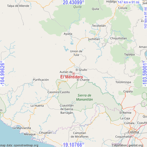
El Mentidero GPS coordinates[2]
19° 46' 14.52" North, 104° 17' 35.268" West
| Map corner | latitude | longitude |
|---|---|---|
| Upper-left | 20.43099°, | -104.99626° |
| Center: | 19.7707°, | -104.29313° |
| Lower-right: | 19.10766°, | -103.59001° |
| Map W x H: | 147.1×147.1 km | = 91.4×91.4mi |
| max Lat: | 32.7° ⇑48% North |
| El Mentidero: | 19.7707° |
| min Lat: | ⇓52% South 14.53588° |
| min Long | El Mentidero | max Long |
| -117.105° | -104.29313° | -86.73105° |
| W 9.4%⇐ | ⇒90.6% E |
Elevation
Elevation of El Mentidero is 886 m = 2907 ft, and this is 367.7 m = 1206 ft below average elevation for this country.
| Max E: |
3497 m = 11473 ft | 61.9% |
| Avg. | 1253.7 m = 4113 ft | |
| El Mentidero | 886 m = 2907 ft | |
Min E: |
-1 m = -3 ft | 38.1% |
See also: Mexico elevation on elevation.city.
Geographical zone
El Mentidero is located in North Torrid zone (between Equator and Tropic of Cancer). Distance of this Northern Tropic circle is 407.6 km =253.3 mi to North.| Distance of | km | miles | from El Mentidero |
|---|---|---|---|
| North Pole | 7808.8 | 4852.2 | to North |
| Arctic Circle | 5202.9 | 3232.9 | to North |
| Tropic Cancer | 407.6 | 253.3 | to North |
| Equator | 2198.3 | 1366 | to South |


Nearby cities:
15 places around El Mentidero: (largest is in red/bold)
• Ahuacapán
10.8 km =6.7 mi,  198°
198°
• Autlán de Navarro
7.7 km =4.8 mi,  267°
267°
• Ayuquila
8 km =5 mi,  15°
15°
• Ejutla
20.3 km =12.6 mi,  42°
42°
• El Cacalote
8.3 km =5.2 mi,  8°
8°
• El Chante
11.3 km =7 mi,  121°
121°
• El Corcovado
8.3 km =5.2 mi, 5°
• El Grullo
8.8 km =5.5 mi,  63°
63°
• El Limón
15.6 km =9.7 mi,  66°
66°
• La Ciénega
17.9 km =11.1 mi, 65°
• La Tijera
18.2 km =11.3 mi,  322°
322°
• Las Lagunillas
6 km =3.7 mi,  175°
175°
• Las Paredes
4.8 km =3 mi,  87°
87°
• Mezquitán
7.2 km =4.5 mi, 322°
• Unión de Tula
20.8 km =12.9 mi, 7°
Sources, notices
• [Note1] Compared only with cities in Mexico existing in our database
• [Src1] Map data: © OpenStreetMap contributors (CC-BY-SA)
• [Src2] Other city data from geonames.org with taken over terms of usage.
• [Src3] Geographical zone / Annual Mean Temperature by Robert A. Rohde @ Wikipedia
