El Grullo geodata
El Grullo (Jalisco) is a seat of a second-order administrative division; located in Mexico in America/Mexico_City (GMT-6) time zone. With population of 20,924 people, there are 486 cities with bigger population in this country. Compared to other cities in Mexico, 52.9% of cities are located further ↓South; 90.4% of cities are located further →East and 62.1% of cities have higher elevation than El Grullo. Note1


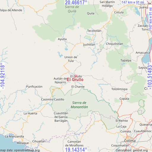
El Grullo GPS coordinates[2]
19° 48' 21.708" North, 104° 13' 4.98" West
| Map corner | latitude | longitude |
|---|---|---|
| Upper-left | 20.46617°, | -104.92118° |
| Center: | 19.80603°, | -104.21805° |
| Lower-right: | 19.14314°, | -103.51493° |
| Map W x H: | 147.1×147.1 km | = 91.4×91.4mi |
| max Lat: | 32.7° ⇑47.1% North |
| El Grullo: | 19.80603° |
| min Lat: | ⇓52.9% South 14.53588° |
| min Long | El Grullo | max Long |
| -117.105° | -104.21805° | -86.73105° |
| W 9.6%⇐ | ⇒90.4% E |
Elevation
Elevation of El Grullo is 878 m = 2881 ft, and this is 375.7 m = 1233 ft below average elevation for this country.
| Max E: |
3497 m = 11473 ft | 62.1% |
| Avg. | 1253.7 m = 4113 ft | |
| El Grullo | 878 m = 2881 ft | |
Min E: |
-1 m = -3 ft | 37.9% |
See also: Mexico elevation on elevation.city.
Geographical zone
El Grullo is located in North Torrid zone (between Equator and Tropic of Cancer). Distance of this Northern Tropic circle is 403.7 km =250.8 mi to North.| Distance of | km | miles | from El Grullo |
|---|---|---|---|
| North Pole | 7804.8 | 4849.7 | to North |
| Arctic Circle | 5198.9 | 3230.4 | to North |
| Tropic Cancer | 403.7 | 250.8 | to North |
| Equator | 2202.2 | 1368.4 | to South |


Nearby cities:
15 places around El Grullo: (largest is in red/bold)
• Ahuacapán
18.1 km =11.2 mi,  218°
218°
• Autlán de Navarro
16.1 km =10 mi,  254°
254°
• Ayuquila
6.8 km =4.2 mi,  303°
303°
• Ejutla
12.5 km =7.8 mi,  28°
28°
• El Cacalote
7.8 km =4.8 mi, 302°
• El Chante
10 km =6.2 mi,  169°
169°
• El Corcovado
8.3 km =5.2 mi, 301°
• El Limón
6.8 km =4.2 mi,  71°
71°
• El Mentidero
8.8 km =5.5 mi,  243°
243°
• La Ciénega
9.1 km =5.7 mi, 67°
• La Tijera
21.7 km =13.5 mi, 298°
• Las Lagunillas
12.3 km =7.6 mi, 216°
• Las Paredes
4.8 km =3 mi, 219°
• Mezquitán
12.4 km =7.7 mi,  278°
278°
• Unión de Tula
17.5 km =10.9 mi,  342°
342°
Sources, notices
• [Note1] Compared only with cities in Mexico existing in our database
• [Src1] Map data: © OpenStreetMap contributors (CC-BY-SA)
• [Src2] Other city data from geonames.org with taken over terms of usage.
• [Src3] Geographical zone / Annual Mean Temperature by Robert A. Rohde @ Wikipedia
