El Fuerte geodata
El Fuerte (San Luis Potosí) is a populated place; located in Mexico in America/Mexico_City (GMT-6) time zone. With population of 1,744 people, there are 4977 cities with bigger population in this country. Compared to other cities in Mexico, 82.5% of cities are located further ↓South; 70.8% of cities are located further →East and 61.3% of cities have lower elevation than El Fuerte. Note1


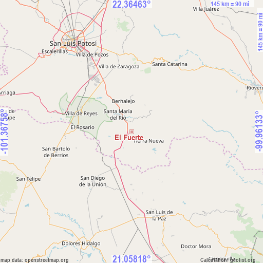
El Fuerte GPS coordinates[2]
21° 42' 46.404" North, 100° 39' 52.02" West
| Map corner | latitude | longitude |
|---|---|---|
| Upper-left | 22.36463°, | -101.36758° |
| Center: | 21.71289°, | -100.66445° |
| Lower-right: | 21.05818°, | -99.96133° |
| Map W x H: | 145.3×145.3 km | = 90.3×90.3mi |
| max Lat: | 32.7° ⇑17.5% North |
| El Fuerte: | 21.71289° |
| min Lat: | ⇓82.5% South 14.53588° |
| min Long | El Fuerte | max Long |
| -117.105° | -100.66445° | -86.73105° |
| W 29.2%⇐ | ⇒70.8% E |
Elevation
Elevation of El Fuerte is 1748 m = 5735 ft, and this is 494.3 m = 1622 ft above average elevation for this country.
| Max E: |
3497 m = 11473 ft | 38.7% |
| El Fuerte | 1748 m 5735 ft | |
| Avg. | 1253.7 m = 4113 ft | |
Min E: |
-1 m = -3 ft | 61.3% |
See also: Mexico elevation on elevation.city.
Geographical zone
El Fuerte is located in North Torrid zone (between Equator and Tropic of Cancer). Distance of this Northern Tropic circle is 191.7 km =119.1 mi to North.| Distance of | km | miles | from El Fuerte |
|---|---|---|---|
| North Pole | 7592.8 | 4717.9 | to North |
| Arctic Circle | 4986.9 | 3098.7 | to North |
| Tropic Cancer | 191.7 | 119.1 | to North |
| Equator | 2414.2 | 1500.1 | to South |


Nearby cities:
15 places around El Fuerte: (largest is in red/bold)
• Cañada de Yáñez
11.1 km =6.9 mi,  5°
5°
• Ejido la Pitahaya (Santo Domingo)
15.5 km =9.6 mi,  220°
220°
• El Cerrito
5.9 km =3.7 mi,  333°
333°
• Enramadas
22.5 km =14 mi, 327°
• Estancia de Atotonilco
14.9 km =9.3 mi,  229°
229°
• Guanajuatito (Cerrito de la Cruz)
14.6 km =9.1 mi,  317°
317°
• La Barranca
13.1 km =8.1 mi,  311°
311°
• La Cardona
9.6 km =6 mi, 305°
• Ojo Caliente
17.5 km =10.9 mi, 328°
• Parritas
24.8 km =15.4 mi,  208°
208°
• Santa María del Río
12 km =7.5 mi, 320°
• Sánchez
8.9 km =5.5 mi,  338°
338°
• Tierra Nueva
10.6 km =6.6 mi,  117°
117°
• Villela
7.3 km =4.5 mi,  237°
237°
• Yerbabuena
11 km =6.8 mi,  254°
254°
Sources, notices
• [Note1] Compared only with cities in Mexico existing in our database
• [Src1] Map data: © OpenStreetMap contributors (CC-BY-SA)
• [Src2] Other city data from geonames.org with taken over terms of usage.
• [Src3] Geographical zone / Annual Mean Temperature by Robert A. Rohde @ Wikipedia
