Enramadas geodata
Enramadas (San Luis Potosí) is a populated place; located in Mexico in America/Mexico_City (GMT-6) time zone. With population of 1,355 people, there are 6421 cities with bigger population in this country. Compared to other cities in Mexico, 83.4% of cities are located further ↓South; 71.7% of cities are located further →East and 64.6% of cities have lower elevation than Enramadas. Note1


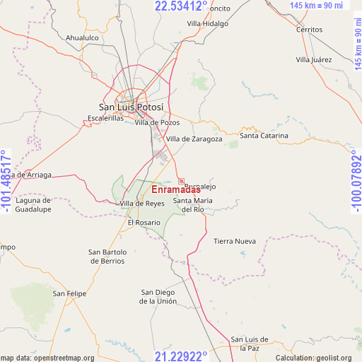
Enramadas GPS coordinates[2]
21° 52' 59.376" North, 100° 46' 55.344" West
| Map corner | latitude | longitude |
|---|---|---|
| Upper-left | 22.53412°, | -101.48517° |
| Center: | 21.88316°, | -100.78204° |
| Lower-right: | 21.22922°, | -100.07892° |
| Map W x H: | 145.1×145.1 km | = 90.2×90.2mi |
| max Lat: | 32.7° ⇑16.6% North |
| Enramadas: | 21.88316° |
| min Lat: | ⇓83.4% South 14.53588° |
| min Long | Enramadas | max Long |
| -117.105° | -100.78204° | -86.73105° |
| W 28.3%⇐ | ⇒71.7% E |
Elevation
Elevation of Enramadas is 1817 m = 5961 ft, and this is 563.3 m = 1848 ft above average elevation for this country.
| Max E: |
3497 m = 11473 ft | 35.4% |
| Enramadas | 1817 m 5961 ft | |
| Avg. | 1253.7 m = 4113 ft | |
Min E: |
-1 m = -3 ft | 64.6% |
See also: Mexico elevation on elevation.city.
Geographical zone
Enramadas is located in North Torrid zone (between Equator and Tropic of Cancer). Distance of this Northern Tropic circle is 172.7 km =107.3 mi to North.| Distance of | km | miles | from Enramadas |
|---|---|---|---|
| North Pole | 7573.9 | 4706.2 | to North |
| Arctic Circle | 4968 | 3087 | to North |
| Tropic Cancer | 172.7 | 107.3 | to North |
| Equator | 2433.2 | 1511.9 | to South |


Nearby cities:
15 places around Enramadas: (largest is in red/bold)
• Cerro Gordo
10.5 km =6.5 mi,  345°
345°
• Ejido Gogorrón (Ex-Hacienda de Gogorrón)
14.2 km =8.8 mi,  250°
250°
• El Mirador
7.6 km =4.7 mi,  280°
280°
• Guanajuatito (Cerrito de la Cruz)
8.5 km =5.3 mi,  164°
164°
• La Barranca
10.5 km =6.5 mi,  166°
166°
• La Cardona
14 km =8.7 mi, 161°
• La Esperanza
14 km =8.7 mi,  7°
7°
• Laguna de San Vicente
10.6 km =6.6 mi,  311°
311°
• Ojo Caliente
5 km =3.1 mi,  144°
144°
• Pardo
7.6 km =4.7 mi,  270°
270°
• San Lorenzo
9.2 km =5.7 mi,  286°
286°
• Santa María del Río
10.7 km =6.6 mi,  154°
154°
• Socavón (El Carmen)
9.9 km =6.2 mi, 249°
• Sánchez
13.9 km =8.6 mi, 140°
• Texas
7.8 km =4.8 mi,  29°
29°
Sources, notices
• [Note1] Compared only with cities in Mexico existing in our database
• [Src1] Map data: © OpenStreetMap contributors (CC-BY-SA)
• [Src2] Other city data from geonames.org with taken over terms of usage.
• [Src3] Geographical zone / Annual Mean Temperature by Robert A. Rohde @ Wikipedia
