El Bajío geodata
El Bajío (Sinaloa) is a populated place; located in Mexico in America/Mazatlan (GMT-7) time zone. With population of 575 people, there are 14908 cities with bigger population in this country. Compared to other cities in Mexico, 88.6% of cities are located further ↓South; 93.9% of cities are located further →East and 86.5% of cities have higher elevation than El Bajío. Note1


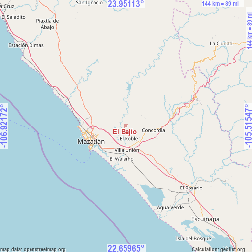
El Bajío GPS coordinates[2]
23° 18' 25.056" North, 106° 13' 6.924" West
| Map corner | latitude | longitude |
|---|---|---|
| Upper-left | 23.95113°, | -106.92172° |
| Center: | 23.30696°, | -106.21859° |
| Lower-right: | 22.65965°, | -105.51547° |
| Map W x H: | 143.6×143.6 km | = 89.2×89.2mi |
| max Lat: | 32.7° ⇑11.4% North |
| El Bajío: | 23.30696° |
| min Lat: | ⇓88.6% South 14.53588° |
| min Long | El Bajío | max Long |
| -117.105° | -106.21859° | -86.73105° |
| W 6.1%⇐ | ⇒93.9% E |
Elevation
Elevation of El Bajío is 36 m = 118 ft, and this is 1217.7 m = 3995 ft below average elevation for this country.
| Max E: |
3497 m = 11473 ft | 86.5% |
| Avg. | 1253.7 m = 4113 ft | |
| El Bajío | 36 m = 118 ft | |
Min E: |
-1 m = -3 ft | 13.5% |
See also: Mexico elevation on elevation.city.
Geographical zone
El Bajío is located in North Torrid zone (between Equator and Tropic of Cancer). Distance of this Northern Tropic circle is 14.4 km =8.9 mi to North.| Distance of | km | miles | from El Bajío |
|---|---|---|---|
| North Pole | 7415.6 | 4607.8 | to North |
| Arctic Circle | 4809.7 | 2988.6 | to North |
| Tropic Cancer | 14.4 | 8.9 | to North |
| Equator | 2591.5 | 1610.3 | to South |


Nearby cities:
15 places around El Bajío: (largest is in red/bold)
• Concordia
16 km =9.9 mi,  98°
98°
• El Recodo
11.1 km =6.9 mi,  3°
3°
• El Roble
7 km =4.3 mi,  169°
169°
• El Vainillo
12 km =7.5 mi,  201°
201°
• El Verde
10.7 km =6.6 mi,  53°
53°
• Escamillas
4.8 km =3 mi,  216°
216°
• Fraccionamiento los Ángeles
17.4 km =10.8 mi, 220°
• La Concepción
11 km =6.8 mi,  27°
27°
• Lomas de Monterrey
7 km =4.3 mi,  213°
213°
• Malpica
10.8 km =6.7 mi,  123°
123°
• San Francisquito
8 km =5 mi, 206°
• Siqueros
4.5 km =2.8 mi,  329°
329°
• Tepuxta
12 km =7.5 mi,  9°
9°
• Villa Unión
13 km =8.1 mi,  180°
180°
• Zavala
11.7 km =7.3 mi,  65°
65°
Sources, notices
• [Note1] Compared only with cities in Mexico existing in our database
• [Src1] Map data: © OpenStreetMap contributors (CC-BY-SA)
• [Src2] Other city data from geonames.org with taken over terms of usage.
• [Src3] Geographical zone / Annual Mean Temperature by Robert A. Rohde @ Wikipedia
