Tinaja de Pastores geodata
Tinaja de Pastores (Guanajuato) is a populated place; located in Mexico in America/Mexico_City (GMT-6) time zone. With population of 924 people, there are 9451 cities with bigger population in this country. Compared to other cities in Mexico, 61.3% of cities are located further ↓South; 73.9% of cities are located further →East and 60.8% of cities have lower elevation than Tinaja de Pastores. Note1


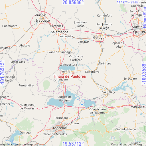
Tinaja de Pastores GPS coordinates[2]
20° 11' 54.204" North, 101° 3' 43.272" West
| Map corner | latitude | longitude |
|---|---|---|
| Upper-left | 20.85686°, | -101.76515° |
| Center: | 20.19839°, | -101.06202° |
| Lower-right: | 19.53712°, | -100.3589° |
| Map W x H: | 146.7×146.7 km | = 91.2×91.2mi |
| max Lat: | 32.7° ⇑38.7% North |
| Tinaja de Pastores: | 20.19839° |
| min Lat: | ⇓61.3% South 14.53588° |
| min Long | Tinaja de Pasto | max Long |
| -117.105° | -101.06202° | -86.73105° |
| W 26.1%⇐ | ⇒73.9% E |
Elevation
Elevation of Tinaja de Pastores is 1741 m = 5712 ft, and this is 487.3 m = 1599 ft above average elevation for this country.
| Max E: |
3497 m = 11473 ft | 39.2% |
| Tinaja de Pastores | 1741 m 5712 ft | |
| Avg. | 1253.7 m = 4113 ft | |
Min E: |
-1 m = -3 ft | 60.8% |
See also: Mexico elevation on elevation.city.
Geographical zone
Tinaja de Pastores is located in North Torrid zone (between Equator and Tropic of Cancer). Distance of this Northern Tropic circle is 360.1 km =223.8 mi to North.| Distance of | km | miles | from Tinaja de Pastores |
|---|---|---|---|
| North Pole | 7761.2 | 4822.6 | to North |
| Arctic Circle | 5155.3 | 3203.4 | to North |
| Tropic Cancer | 360.1 | 223.8 | to North |
| Equator | 2245.9 | 1395.5 | to South |


Nearby cities:
15 places around Tinaja de Pastores: (largest is in red/bold)
• Cervacio Mendoza
4.1 km =2.5 mi,  75°
75°
• Colonia Juárez
10.8 km =6.7 mi,  236°
236°
• Cupareo
5.7 km =3.5 mi,  53°
53°
• El Charco
9.2 km =5.7 mi,  229°
229°
• El Salteador
6.7 km =4.2 mi,  193°
193°
• La Angostura
10.1 km =6.3 mi,  330°
330°
• Loma de Zempoala
10.6 km =6.6 mi,  349°
349°
• Maravatío del Encinal
10.5 km =6.5 mi,  85°
85°
• Parangarico
10.8 km =6.7 mi,  266°
266°
• Porullo
4.9 km =3 mi, 226°
• Puerta del Monte
7.7 km =4.8 mi,  29°
29°
• Santa Rita de Casia
7.8 km =4.8 mi, 90°
• Santa Teresa (La Majada)
10.7 km =6.6 mi,  98°
98°
• Santiago Maravatío
7.6 km =4.7 mi,  111°
111°
• Yuriria
7.4 km =4.6 mi,  280°
280°
Sources, notices
• [Note1] Compared only with cities in Mexico existing in our database
• [Src1] Map data: © OpenStreetMap contributors (CC-BY-SA)
• [Src2] Other city data from geonames.org with taken over terms of usage.
• [Src3] Geographical zone / Annual Mean Temperature by Robert A. Rohde @ Wikipedia
