Coyotitán geodata
Coyotitán (Sinaloa) is a populated place; located in Mexico in America/Mazatlan (GMT-7) time zone. With population of 1,676 people, there are 5176 cities with bigger population in this country. Compared to other cities in Mexico, 89.4% of cities are located further ↓South; 94.2% of cities are located further →East and 81.1% of cities have higher elevation than Coyotitán. Note1


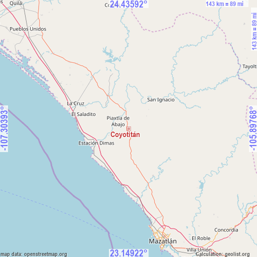
Coyotitán GPS coordinates[2]
23° 47' 38.976" North, 106° 36' 2.88" West
| Map corner | latitude | longitude |
|---|---|---|
| Upper-left | 24.43592°, | -107.30393° |
| Center: | 23.79416°, | -106.6008° |
| Lower-right: | 23.14922°, | -105.89768° |
| Map W x H: | 143.1×143.1 km | = 88.9×88.9mi |
| max Lat: | 32.7° ⇑10.6% North |
| Coyotitán: | 23.79416° |
| min Lat: | ⇓89.4% South 14.53588° |
| min Long | Coyotitán | max Long |
| -117.105° | -106.6008° | -86.73105° |
| W 5.8%⇐ | ⇒94.2% E |
Elevation
Elevation of Coyotitán is 81 m = 266 ft, and this is 1172.7 m = 3847 ft below average elevation for this country.
| Max E: |
3497 m = 11473 ft | 81.1% |
| Avg. | 1253.7 m = 4113 ft | |
| Coyotitán | 81 m = 266 ft | |
Min E: |
-1 m = -3 ft | 18.9% |
See also: Mexico elevation on elevation.city.
Geographical zone
Coyotitán is located in North temperate zone (between Tropic of Cancer and the Arctic Circle). Distance of this Northern Tropic circle is 39.7 km =24.7 mi to South.| Distance of | km | miles | from Coyotitán |
|---|---|---|---|
| North Pole | 7361.4 | 4574.2 | to North |
| Arctic Circle | 4755.5 | 2954.9 | to North |
| Tropic Cancer | 39.7 | 24.7 | to South |
| Equator | 2645.7 | 1644 | to South |


Nearby cities:
15 places around Coyotitán: (largest is in red/bold)
• Casas Viejas
34.4 km =21.4 mi,  321°
321°
• Celestino Gazca Villaseñor
28.5 km =17.7 mi,  275°
275°
• Ceuta
35.4 km =22 mi,  289°
289°
• El Bolillo
33.5 km =20.8 mi, 318°
• El Quelite
29.5 km =18.3 mi,  152°
152°
• El Quemado
31.4 km =19.5 mi,  157°
157°
• El Roble
26.4 km =16.4 mi,  303°
303°
• El Saladito
26.5 km =16.5 mi, 288°
• El Salado
26.7 km =16.6 mi, 295°
• Elota
22.5 km =14 mi,  330°
330°
• La Cruz
32.9 km =20.4 mi, 295°
• Piaxtla de Abajo
7.3 km =4.5 mi,  305°
305°
• San Ignacio
24.2 km =15 mi,  47°
47°
• San Juan
29.7 km =18.5 mi,  71°
71°
• Tayoltita
27.9 km =17.3 mi, 285°
Sources, notices
• [Note1] Compared only with cities in Mexico existing in our database
• [Src1] Map data: © OpenStreetMap contributors (CC-BY-SA)
• [Src2] Other city data from geonames.org with taken over terms of usage.
• [Src3] Geographical zone / Annual Mean Temperature by Robert A. Rohde @ Wikipedia
