Cosío geodata
Cosío (Aguascalientes) is a seat of a second-order administrative division; located in Mexico in America/Mexico_City (GMT-6) time zone. With population of 4,898 people, there are 1887 cities with bigger population in this country. Compared to other cities in Mexico, 86.1% of cities are located further ↓South; 82.8% of cities are located further →East and 73.7% of cities have lower elevation than Cosío. Note1


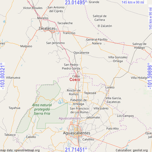
Cosío GPS coordinates[2]
22° 21' 58.5" North, 102° 18' 0.288" West
| Map corner | latitude | longitude |
|---|---|---|
| Upper-left | 23.01495°, | -103.00321° |
| Center: | 22.36625°, | -102.30008° |
| Lower-right: | 21.71451°, | -101.59696° |
| Map W x H: | 144.6×144.6 km | = 89.9×89.9mi |
| max Lat: | 32.7° ⇑13.9% North |
| Cosío: | 22.36625° |
| min Lat: | ⇓86.1% South 14.53588° |
| min Long | Cosío | max Long |
| -117.105° | -102.30008° | -86.73105° |
| W 17.2%⇐ | ⇒82.8% E |
Elevation
Elevation of Cosío is 2005 m = 6578 ft, and this is 751.3 m = 2465 ft above average elevation for this country.
| Max E: |
3497 m = 11473 ft | 26.3% |
| Cosío | 2005 m 6578 ft | |
| Avg. | 1253.7 m = 4113 ft | |
Min E: |
-1 m = -3 ft | 73.7% |
See also: Mexico elevation on elevation.city.
Geographical zone
Cosío is located in North Torrid zone (between Equator and Tropic of Cancer). Distance of this Northern Tropic circle is 119 km =73.9 mi to North.| Distance of | km | miles | from Cosío |
|---|---|---|---|
| North Pole | 7520.2 | 4672.8 | to North |
| Arctic Circle | 4914.3 | 3053.6 | to North |
| Tropic Cancer | 119 | 73.9 | to North |
| Equator | 2486.9 | 1545.3 | to South |


Nearby cities:
15 places around Cosío: (largest is in red/bold)
• California
10.3 km =6.4 mi,  150°
150°
• El Refugio de Agua Zarca
2.5 km =1.6 mi,  103°
103°
• El Refugio de Providencia (Providencia)
4.9 km =3 mi,  116°
116°
• El Salero
3.3 km =2.1 mi,  314°
314°
• El Valle de las Delicias
10 km =6.2 mi, 123°
• La Punta
4.8 km =3 mi,  170°
170°
• Luis Moya
9.1 km =5.7 mi,  35°
35°
• Puerta del Muerto
9.4 km =5.8 mi, 145°
• Rancho Nuevo
6.8 km =4.2 mi, 312°
• San Jacinto
7.1 km =4.4 mi,  106°
106°
• San Juan de la Natura
8.1 km =5 mi,  92°
92°
• San Pedro Piedra Gorda
10.3 km =6.4 mi,  331°
331°
• Santa María de la Paz
5 km =3.1 mi,  61°
61°
• Soledad de Abajo
4.9 km =3 mi,  17°
17°
• Soledad de Arriba
7.4 km =4.6 mi,  354°
354°
Sources, notices
• [Note1] Compared only with cities in Mexico existing in our database
• [Src1] Map data: © OpenStreetMap contributors (CC-BY-SA)
• [Src2] Other city data from geonames.org with taken over terms of usage.
• [Src3] Geographical zone / Annual Mean Temperature by Robert A. Rohde @ Wikipedia
