El Salero geodata
El Salero (Aguascalientes) is a populated place; located in Mexico in America/Mexico_City (GMT-6) time zone. With population of 1,229 people, there are 7060 cities with bigger population in this country. Compared to other cities in Mexico, 86.2% of cities are located further ↓South; 83% of cities are located further →East and 75.3% of cities have lower elevation than El Salero. Note1


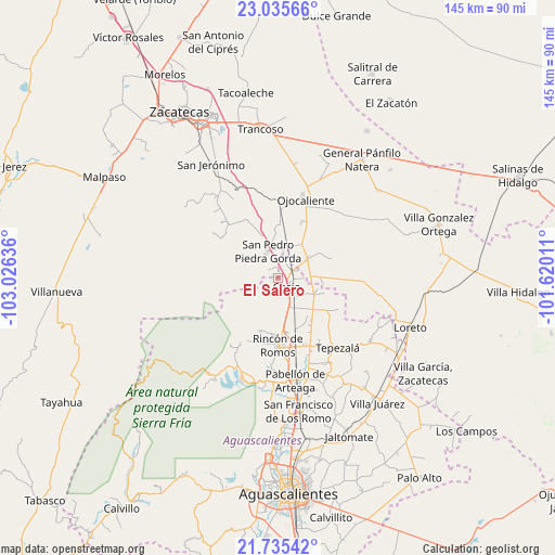
El Salero GPS coordinates[2]
22° 23' 13.416" North, 102° 19' 23.628" West
| Map corner | latitude | longitude |
|---|---|---|
| Upper-left | 23.03566°, | -103.02636° |
| Center: | 22.38706°, | -102.32323° |
| Lower-right: | 21.73542°, | -101.62011° |
| Map W x H: | 144.6×144.6 km | = 89.9×89.9mi |
| max Lat: | 32.7° ⇑13.8% North |
| El Salero: | 22.38706° |
| min Lat: | ⇓86.2% South 14.53588° |
| min Long | El Salero | max Long |
| -117.105° | -102.32323° | -86.73105° |
| W 17%⇐ | ⇒83% E |
Elevation
Elevation of El Salero is 2035 m = 6677 ft, and this is 781.3 m = 2563 ft above average elevation for this country.
| Max E: |
3497 m = 11473 ft | 24.7% |
| El Salero | 2035 m 6677 ft | |
| Avg. | 1253.7 m = 4113 ft | |
Min E: |
-1 m = -3 ft | 75.3% |
See also: Mexico elevation on elevation.city.
Geographical zone
El Salero is located in North Torrid zone (between Equator and Tropic of Cancer). Distance of this Northern Tropic circle is 116.7 km =72.5 mi to North.| Distance of | km | miles | from El Salero |
|---|---|---|---|
| North Pole | 7517.9 | 4671.4 | to North |
| Arctic Circle | 4912 | 3052.2 | to North |
| Tropic Cancer | 116.7 | 72.5 | to North |
| Equator | 2489.2 | 1546.7 | to South |


Nearby cities:
15 places around El Salero: (largest is in red/bold)
• Cosío
3.3 km =2.1 mi,  134°
134°
• El Refugio de Agua Zarca
5.6 km =3.5 mi,  120°
120°
• El Refugio de Providencia (Providencia)
8.1 km =5 mi, 123°
• Esteban S. Castorena
10.6 km =6.6 mi,  37°
37°
• La Punta
7.7 km =4.8 mi,  155°
155°
• Los Griegos
12.7 km =7.9 mi,  57°
57°
• Luis Moya
9.2 km =5.7 mi, 56°
• Puerta del Muerto
12.7 km =7.9 mi,  142°
142°
• Rancho Nuevo
3.5 km =2.2 mi,  311°
311°
• San Jacinto
10.2 km =6.3 mi,  114°
114°
• San Juan de la Natura
10.8 km =6.7 mi,  104°
104°
• San Pedro Piedra Gorda
7.2 km =4.5 mi,  338°
338°
• Santa María de la Paz
6.8 km =4.2 mi,  89°
89°
• Soledad de Abajo
4.5 km =2.8 mi, 58°
• Soledad de Arriba
5.3 km =3.3 mi,  17°
17°
Sources, notices
• [Note1] Compared only with cities in Mexico existing in our database
• [Src1] Map data: © OpenStreetMap contributors (CC-BY-SA)
• [Src2] Other city data from geonames.org with taken over terms of usage.
• [Src3] Geographical zone / Annual Mean Temperature by Robert A. Rohde @ Wikipedia
