Juárez geodata
Juárez (Chihuahua) is a seat of a second-order administrative division; located in Mexico in America/Ojinaga (GMT-5) time zone. With population of 1,321,004 people, there are 5 cities with bigger population in this country. Compared to other cities in Mexico, 99.2% of cities are located further ↓South; 94.1% of cities are located further →East and 56.9% of cities have higher elevation than Juárez. Note1


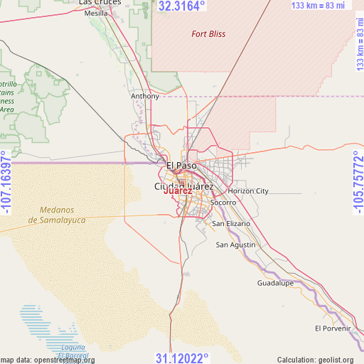
Juárez GPS coordinates[2]
31° 43' 12.864" North, 106° 27' 39.024" West
| Map corner | latitude | longitude |
|---|---|---|
| Upper-left | 32.3164°, | -107.16397° |
| Center: | 31.72024°, | -106.46084° |
| Lower-right: | 31.12022°, | -105.75772° |
| Map W x H: | 133×133 km | = 82.6×82.6mi |
| max Lat: | 32.7° ⇑0.8% North |
| Juárez: | 31.72024° |
| min Lat: | ⇓99.2% South 14.53588° |
| min Long | Juárez | max Long |
| -117.105° | -106.46084° | -86.73105° |
| W 5.9%⇐ | ⇒94.1% E |
Elevation
Elevation of Juárez is 1124 m = 3688 ft, and this is 129.7 m = 426 ft below average elevation for this country.
| Max E: |
3497 m = 11473 ft | 56.9% |
| Avg. | 1253.7 m = 4113 ft | |
| Juárez | 1124 m = 3688 ft | |
Min E: |
-1 m = -3 ft | 43.1% |
See also: Juárez elevation on elevation.city.
Geographical zone
Juárez is located in North temperate zone (between Tropic of Cancer and the Arctic Circle). Distance of this Northern Tropic circle is 921 km =572.3 mi to South.| Distance of | km | miles | from Juárez |
|---|---|---|---|
| North Pole | 6480.1 | 4026.5 | to North |
| Arctic Circle | 3874.2 | 2407.3 | to North |
| Tropic Cancer | 921 | 572.3 | to South |
| Equator | 3527 | 2191.6 | to South |


Nearby cities:
15 places around Juárez: (largest is in red/bold)
• Barreales
47 km =29.2 mi,  139°
139°
• Esperanza
64.2 km =39.9 mi,  132°
132°
• Guadalupe
49.8 km =30.9 mi, 137°
• Jesús Carranza (La Colorada)
33.1 km =20.6 mi, 139°
• Juárez y Reforma
41.6 km =25.8 mi, 138°
• Loma Blanca
22.1 km =13.7 mi, 134°
• Porvenir
76.9 km =47.8 mi, 133°
• Praxedis G. Guerrero
58 km =36 mi, 132°
• Praxédis Guerrero
57.6 km =35.8 mi, 133°
• Puerto Palomas
111.1 km =69 mi,  273°
273°
• Rinconada del Mimbre
57.1 km =35.5 mi, 136°
• Samalayuca
42 km =26.1 mi,  182°
182°
• San Agustín
29.8 km =18.5 mi, 139°
• San Isidro
25.9 km =16.1 mi, 138°
• Tres Jacales
38.1 km =23.7 mi, 139°
In other languages:
- In Spanish: Ciudad Juárez, Juárez
- In France: Ciudad Juárez
- In German: Ciudad Juárez
- In Italian: Ciudad Juárez
- In Russian: Сьюдад-Хуарес
- In Chinese: 華雷斯城
Sources, notices
• [Note1] Compared only with cities in Mexico existing in our database
• [Src1] Map data: © OpenStreetMap contributors (CC-BY-SA)
• [Src2] Other city data from geonames.org with taken over terms of usage.
• [Src3] Geographical zone / Annual Mean Temperature by Robert A. Rohde @ Wikipedia
