Praxédis Guerrero geodata
Praxédis Guerrero (Chihuahua) is a populated place; located in Mexico in America/Chihuahua (GMT-6) time zone. With population of 3,787 people, there are 2416 cities with bigger population in this country. Compared to other cities in Mexico, 99.1% of cities are located further ↓South; 93.8% of cities are located further →East and 58.5% of cities have higher elevation than Praxédis Guerrero. Note1


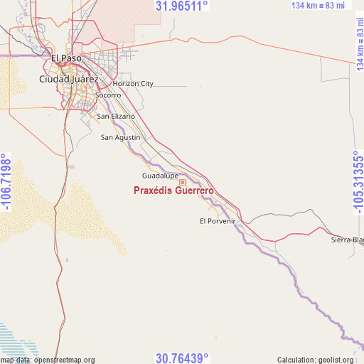
Praxédis Guerrero GPS coordinates[2]
31° 22' 0.012" North, 106° 1' 0.012" West
| Map corner | latitude | longitude |
|---|---|---|
| Upper-left | 31.96511°, | -106.7198° |
| Center: | 31.36667°, | -106.01667° |
| Lower-right: | 30.76439°, | -105.31355° |
| Map W x H: | 133.5×133.5 km | = 83×83mi |
| max Lat: | 32.7° ⇑0.9% North |
| Praxédis Guerrero: | 31.36667° |
| min Lat: | ⇓99.1% South 14.53588° |
| min Long | Praxédis Guerr | max Long |
| -117.105° | -106.01667° | -86.73105° |
| W 6.2%⇐ | ⇒93.8% E |
Elevation
Elevation of Praxédis Guerrero is 1082 m = 3550 ft, and this is 171.7 m = 563 ft below average elevation for this country.
| Max E: |
3497 m = 11473 ft | 58.5% |
| Avg. | 1253.7 m = 4113 ft | |
| Praxédis Guerrero | 1082 m = 3550 ft | |
Min E: |
-1 m = -3 ft | 41.5% |
See also: Mexico elevation on elevation.city.
Geographical zone
Praxédis Guerrero is located in North temperate zone (between Tropic of Cancer and the Arctic Circle). Distance of this Northern Tropic circle is 881.7 km =547.9 mi to South.| Distance of | km | miles | from Praxédis Guerrero |
|---|---|---|---|
| North Pole | 6519.4 | 4051 | to North |
| Arctic Circle | 3913.5 | 2431.7 | to North |
| Tropic Cancer | 881.7 | 547.9 | to South |
| Equator | 3487.6 | 2167.1 | to South |


Nearby cities:
15 places around Praxédis Guerrero: (largest is in red/bold)
• Barreales
12.1 km =7.5 mi,  286°
286°
• Esperanza
6.6 km =4.1 mi,  127°
127°
• Guadalupe
8.8 km =5.5 mi, 286°
• Jesús Carranza (La Colorada)
25 km =15.5 mi,  303°
303°
• Juárez
57.6 km =35.8 mi,  313°
313°
• Juárez y Reforma
16.7 km =10.4 mi, 299°
• Loma Blanca
35.6 km =22.1 mi, 311°
• Miguel Ahumada
95.7 km =59.5 mi,  209°
209°
• Porvenir
19.3 km =12 mi,  136°
136°
• Praxedis G. Guerrero
1.1 km =0.7 mi,  66°
66°
• Rinconada del Mimbre
3.7 km =2.3 mi,  233°
233°
• Samalayuca
44.1 km =27.4 mi,  266°
266°
• San Agustín
28.1 km =17.5 mi, 306°
• San Isidro
31.9 km =19.8 mi, 308°
• Tres Jacales
20.3 km =12.6 mi, 300°
Sources, notices
• [Note1] Compared only with cities in Mexico existing in our database
• [Src1] Map data: © OpenStreetMap contributors (CC-BY-SA)
• [Src2] Other city data from geonames.org with taken over terms of usage.
• [Src3] Geographical zone / Annual Mean Temperature by Robert A. Rohde @ Wikipedia
