Cieneguilla geodata
Cieneguilla (Aguascalientes) is a populated place; located in Mexico in America/Mexico_City (GMT-6) time zone. With population of 989 people, there are 8805 cities with bigger population in this country. Compared to other cities in Mexico, 82.6% of cities are located further ↓South; 83.8% of cities are located further →East and 64.8% of cities have lower elevation than Cieneguilla. Note1


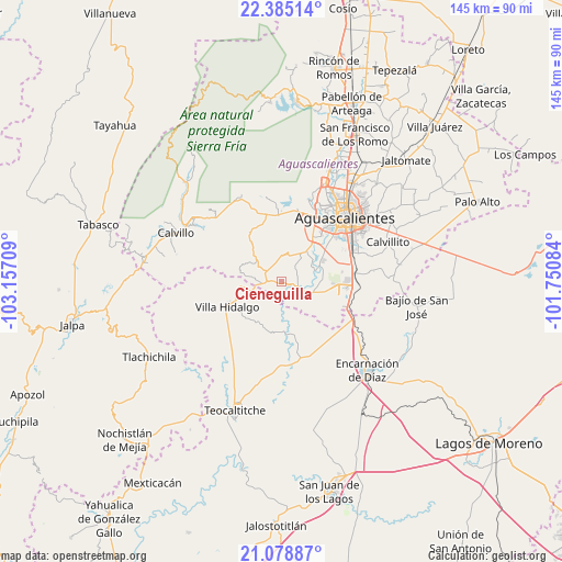
Cieneguilla GPS coordinates[2]
21° 44' 0.564" North, 102° 27' 14.256" West
| Map corner | latitude | longitude |
|---|---|---|
| Upper-left | 22.38514°, | -103.15709° |
| Center: | 21.73349°, | -102.45396° |
| Lower-right: | 21.07887°, | -101.75084° |
| Map W x H: | 145.2×145.2 km | = 90.2×90.2mi |
| max Lat: | 32.7° ⇑17.4% North |
| Cieneguilla: | 21.73349° |
| min Lat: | ⇓82.6% South 14.53588° |
| min Long | Cieneguilla | max Long |
| -117.105° | -102.45396° | -86.73105° |
| W 16.2%⇐ | ⇒83.8% E |
Elevation
Elevation of Cieneguilla is 1823 m = 5981 ft, and this is 569.3 m = 1868 ft above average elevation for this country.
| Max E: |
3497 m = 11473 ft | 35.2% |
| Cieneguilla | 1823 m 5981 ft | |
| Avg. | 1253.7 m = 4113 ft | |
Min E: |
-1 m = -3 ft | 64.8% |
See also: Mexico elevation on elevation.city.
Geographical zone
Cieneguilla is located in North Torrid zone (between Equator and Tropic of Cancer). Distance of this Northern Tropic circle is 189.4 km =117.7 mi to North.| Distance of | km | miles | from Cieneguilla |
|---|---|---|---|
| North Pole | 7590.5 | 4716.5 | to North |
| Arctic Circle | 4984.6 | 3097.3 | to North |
| Tropic Cancer | 189.4 | 117.7 | to North |
| Equator | 2416.5 | 1501.5 | to South |


Nearby cities:
15 places around Cieneguilla: (largest is in red/bold)
• Buenavista de Peñuelas
16.5 km =10.3 mi,  96°
96°
• CERESO (Para Varones y Mujeres)
18.7 km =11.6 mi,  28°
28°
• Centro de Arriba
4.6 km =2.9 mi,  266°
266°
• El Refugio de Peñuelas
17.1 km =10.6 mi, 96°
• El Tanque de los Jiménez
8.8 km =5.5 mi,  108°
108°
• General Ignacio Zaragoza
16.5 km =10.3 mi,  356°
356°
• La Loma de los Negritos
18.6 km =11.6 mi,  35°
35°
• Los Caños
5.5 km =3.4 mi,  345°
345°
• Montoro
15.9 km =9.9 mi,  80°
80°
• Peñuelas (El Cienegal)
18.4 km =11.4 mi,  93°
93°
• Residencial San Nicolás [Baños la Cantera]
16.5 km =10.3 mi, 37°
• San Antonio de Peñuelas
17.2 km =10.7 mi, 112°
• Tapias Viejas
15.4 km =9.6 mi,  326°
326°
• Villa Hidalgo
15.2 km =9.4 mi,  245°
245°
• Villas del Mediterráneo
17.7 km =11 mi,  46°
46°
Sources, notices
• [Note1] Compared only with cities in Mexico existing in our database
• [Src1] Map data: © OpenStreetMap contributors (CC-BY-SA)
• [Src2] Other city data from geonames.org with taken over terms of usage.
• [Src3] Geographical zone / Annual Mean Temperature by Robert A. Rohde @ Wikipedia
