Cerro Agudo geodata
Cerro Agudo (Sinaloa) is a populated place; located in Mexico in America/Mazatlan (GMT-7) time zone. With population of 1,003 people, there are 8693 cities with bigger population in this country. Compared to other cities in Mexico, 93.1% of cities are located further ↓South; 95.6% of cities are located further →East and 77.8% of cities have higher elevation than Cerro Agudo. Note1


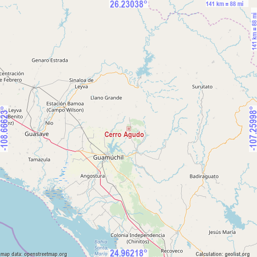
Cerro Agudo GPS coordinates[2]
25° 35' 52.656" North, 107° 57' 47.16" West
| Map corner | latitude | longitude |
|---|---|---|
| Upper-left | 26.23038°, | -108.66623° |
| Center: | 25.59796°, | -107.9631° |
| Lower-right: | 24.96218°, | -107.25998° |
| Map W x H: | 141×141 km | = 87.6×87.6mi |
| max Lat: | 32.7° ⇑6.9% North |
| Cerro Agudo: | 25.59796° |
| min Lat: | ⇓93.1% South 14.53588° |
| min Long | Cerro Agudo | max Long |
| -117.105° | -107.9631° | -86.73105° |
| W 4.4%⇐ | ⇒95.6% E |
Elevation
Elevation of Cerro Agudo is 134 m = 440 ft, and this is 1119.7 m = 3674 ft below average elevation for this country.
| Max E: |
3497 m = 11473 ft | 77.8% |
| Avg. | 1253.7 m = 4113 ft | |
| Cerro Agudo | 134 m = 440 ft | |
Min E: |
-1 m = -3 ft | 22.2% |
See also: Mexico elevation on elevation.city.
Geographical zone
Cerro Agudo is located in North temperate zone (between Tropic of Cancer and the Arctic Circle). Distance of this Northern Tropic circle is 240.3 km =149.3 mi to South.| Distance of | km | miles | from Cerro Agudo |
|---|---|---|---|
| North Pole | 7160.8 | 4449.5 | to North |
| Arctic Circle | 4554.9 | 2830.3 | to North |
| Tropic Cancer | 240.3 | 149.3 | to South |
| Equator | 2846.2 | 1768.5 | to South |


Nearby cities:
15 places around Cerro Agudo: (largest is in red/bold)
• Bacubirito
24 km =14.9 mi,  11°
11°
• Capomos
26.6 km =16.5 mi,  218°
218°
• El Mezquite
9.2 km =5.7 mi,  80°
80°
• El Salitre
24.7 km =15.3 mi, 223°
• El Taballal
22.1 km =13.7 mi,  201°
201°
• Estación Capomas
26.1 km =16.2 mi,  270°
270°
• Francisco R. Serrano
26.4 km =16.4 mi,  254°
254°
• Guamúchil
19.3 km =12 mi, 216°
• Higuera de los Vega
6.4 km =4 mi,  4°
4°
• Llano Grande
21.1 km =13.1 mi,  324°
324°
• Mocorito
13.6 km =8.5 mi,  161°
161°
• Nacaveba
19.9 km =12.4 mi,  336°
336°
• San Benito
20.8 km =12.9 mi,  106°
106°
• San Isidro
24.3 km =15.1 mi, 219°
• Tultita
19.3 km =12 mi,  207°
207°
Sources, notices
• [Note1] Compared only with cities in Mexico existing in our database
• [Src1] Map data: © OpenStreetMap contributors (CC-BY-SA)
• [Src2] Other city data from geonames.org with taken over terms of usage.
• [Src3] Geographical zone / Annual Mean Temperature by Robert A. Rohde @ Wikipedia
