Bacubirito geodata
Bacubirito (Sinaloa) is a populated place; located in Mexico in America/Mazatlan (GMT-7) time zone. With population of 1,172 people, there are 7412 cities with bigger population in this country. Compared to other cities in Mexico, 94.3% of cities are located further ↓South; 95.5% of cities are located further →East and 76.3% of cities have higher elevation than Bacubirito. Note1


Bacubirito GPS coordinates[2]
25° 48' 33.984" North, 107° 54' 54" West
| Map corner | latitude | longitude |
|---|---|---|
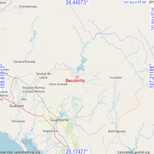
| Upper-left | 26.44073°, | -108.61813° |
| Center: | 25.80944°, | -107.915° |
| Lower-right: | 25.17477°, | -107.21188° |
| Map W x H: | 140.8×140.8 km | = 87.5×87.5mi |
| max Lat: | 32.7° ⇑5.7% North |
| Bacubirito: | 25.80944° |
| min Lat: | ⇓94.3% South 14.53588° |
| min Long | Bacubirito | max Long |
| -117.105° | -107.915° | -86.73105° |
| W 4.5%⇐ | ⇒95.5% E |
Elevation
Elevation of Bacubirito is 174 m = 571 ft, and this is 1079.7 m = 3542 ft below average elevation for this country.
| Max E: |
3497 m = 11473 ft | 76.3% |
| Avg. | 1253.7 m = 4113 ft | |
| Bacubirito | 174 m = 571 ft | |
Min E: |
-1 m = -3 ft | 23.7% |
See also: Mexico elevation on elevation.city.
Geographical zone
Bacubirito is located in North temperate zone (between Tropic of Cancer and the Arctic Circle). Distance of this Northern Tropic circle is 263.8 km =163.9 mi to South.| Distance of | km | miles | from Bacubirito |
|---|---|---|---|
| North Pole | 7137.3 | 4434.9 | to North |
| Arctic Circle | 4531.4 | 2815.7 | to North |
| Tropic Cancer | 263.8 | 163.9 | to South |
| Equator | 2869.7 | 1783.1 | to South |


Nearby cities:
15 places around Bacubirito: (largest is in red/bold)
• Agua Blanca
21.5 km =13.4 mi,  290°
290°
• Baburia
29 km =18 mi,  277°
277°
• Buenavista
21.3 km =13.2 mi, 286°
• Cerro Agudo
24 km =14.9 mi,  191°
191°
• Cubiri de Portelas
34.6 km =21.5 mi,  265°
265°
• El Mezquite
22.4 km =13.9 mi,  169°
169°
• El Opochi
28.8 km =17.9 mi, 271°
• El Pueblito (El Realito)
22.9 km =14.2 mi, 278°
• Higuera de los Vega
17.7 km =11 mi, 194°
• Llano Grande
18.3 km =11.4 mi,  249°
249°
• Maripa
25 km =15.5 mi, 283°
• Maripita
26.6 km =16.5 mi, 280°
• Nacaveba
13.9 km =8.6 mi, 247°
• San Benito
33.2 km =20.6 mi,  152°
152°
• Sinaloa de Leyva
30.8 km =19.1 mi, 272°
Sources, notices
• [Note1] Compared only with cities in Mexico existing in our database
• [Src1] Map data: © OpenStreetMap contributors (CC-BY-SA)
• [Src2] Other city data from geonames.org with taken over terms of usage.
• [Src3] Geographical zone / Annual Mean Temperature by Robert A. Rohde @ Wikipedia
