Cóndiro geodata
Cóndiro (Jalisco) is a populated place; located in Mexico in America/Mexico_City (GMT-6) time zone. With population of 738 people, there are 11838 cities with bigger population in this country. Compared to other cities in Mexico, 65.8% of cities are located further ↓South; 84.3% of cities are located further →East and 54.5% of cities have lower elevation than Cóndiro. Note1


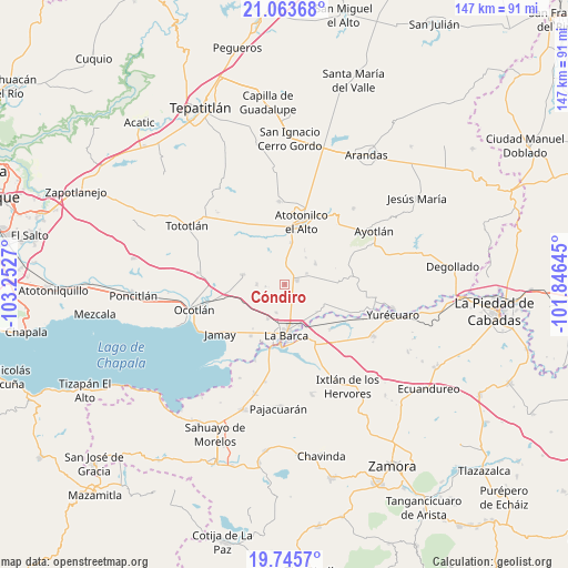
Cóndiro GPS coordinates[2]
20° 24' 21.96" North, 102° 32' 58.452" West
| Map corner | latitude | longitude |
|---|---|---|
| Upper-left | 21.06368°, | -103.2527° |
| Center: | 20.4061°, | -102.54957° |
| Lower-right: | 19.7457°, | -101.84645° |
| Map W x H: | 146.5×146.5 km | = 91×91mi |
| max Lat: | 32.7° ⇑34.2% North |
| Cóndiro: | 20.4061° |
| min Lat: | ⇓65.8% South 14.53588° |
| min Long | Cóndiro | max Long |
| -117.105° | -102.54957° | -86.73105° |
| W 15.7%⇐ | ⇒84.3% E |
Elevation
Elevation of Cóndiro is 1574 m = 5164 ft, and this is 320.3 m = 1051 ft above average elevation for this country.
| Max E: |
3497 m = 11473 ft | 45.5% |
| Cóndiro | 1574 m 5164 ft | |
| Avg. | 1253.7 m = 4113 ft | |
Min E: |
-1 m = -3 ft | 54.5% |
See also: Mexico elevation on elevation.city.
Geographical zone
Cóndiro is located in North Torrid zone (between Equator and Tropic of Cancer). Distance of this Northern Tropic circle is 337 km =209.4 mi to North.| Distance of | km | miles | from Cóndiro |
|---|---|---|---|
| North Pole | 7738.1 | 4808.2 | to North |
| Arctic Circle | 5132.2 | 3189 | to North |
| Tropic Cancer | 337 | 209.4 | to North |
| Equator | 2268.9 | 1409.8 | to South |


Nearby cities:
15 places around Cóndiro: (largest is in red/bold)
• Canales
7.1 km =4.4 mi,  269°
269°
• Cucarachas
8.4 km =5.2 mi,  353°
353°
• El Gobernador
9.9 km =6.2 mi,  100°
100°
• El Mirto
5.5 km =3.4 mi,  175°
175°
• Guayabos
5 km =3.1 mi,  263°
263°
• La Paz de Ordaz
7.1 km =4.4 mi,  163°
163°
• La Puerta de Guamúchil
8.8 km =5.5 mi, 175°
• Margaritas
9.4 km =5.8 mi,  56°
56°
• Nuevo Valle (Ex-Hacienda del Valle)
8.2 km =5.1 mi,  331°
331°
• Portezuelo
3.3 km =2.1 mi,  76°
76°
• San Francisco de Rivas
7.7 km =4.8 mi,  197°
197°
• San Joaquín
9.9 km =6.2 mi,  31°
31°
• San José del Valle
8.2 km =5.1 mi, 327°
• Santa Elena
8.8 km =5.5 mi,  38°
38°
• Villa de García Márquez
6.3 km =3.9 mi, 63°
Sources, notices
• [Note1] Compared only with cities in Mexico existing in our database
• [Src1] Map data: © OpenStreetMap contributors (CC-BY-SA)
• [Src2] Other city data from geonames.org with taken over terms of usage.
• [Src3] Geographical zone / Annual Mean Temperature by Robert A. Rohde @ Wikipedia
