Cucarachas geodata
Cucarachas (Jalisco) is a populated place; located in Mexico in America/Mexico_City (GMT-6) time zone. With population of 519 people, there are 16226 cities with bigger population in this country. Compared to other cities in Mexico, 67.4% of cities are located further ↓South; 84.4% of cities are located further →East and 55.7% of cities have lower elevation than Cucarachas. Note1


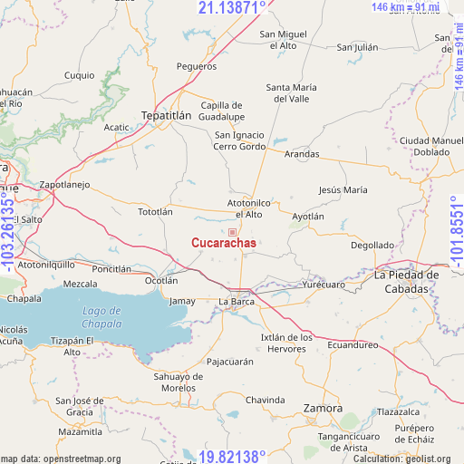
Cucarachas GPS coordinates[2]
20° 28' 53.256" North, 102° 33' 29.592" West
| Map corner | latitude | longitude |
|---|---|---|
| Upper-left | 21.13871°, | -103.26135° |
| Center: | 20.48146°, | -102.55822° |
| Lower-right: | 19.82138°, | -101.8551° |
| Map W x H: | 146.5×146.5 km | = 91×91mi |
| max Lat: | 32.7° ⇑32.6% North |
| Cucarachas: | 20.48146° |
| min Lat: | ⇓67.4% South 14.53588° |
| min Long | Cucarachas | max Long |
| -117.105° | -102.55822° | -86.73105° |
| W 15.6%⇐ | ⇒84.4% E |
Elevation
Elevation of Cucarachas is 1609 m = 5279 ft, and this is 355.3 m = 1166 ft above average elevation for this country.
| Max E: |
3497 m = 11473 ft | 44.3% |
| Cucarachas | 1609 m 5279 ft | |
| Avg. | 1253.7 m = 4113 ft | |
Min E: |
-1 m = -3 ft | 55.7% |
See also: Mexico elevation on elevation.city.
Geographical zone
Cucarachas is located in North Torrid zone (between Equator and Tropic of Cancer). Distance of this Northern Tropic circle is 328.6 km =204.2 mi to North.| Distance of | km | miles | from Cucarachas |
|---|---|---|---|
| North Pole | 7729.7 | 4803 | to North |
| Arctic Circle | 5123.8 | 3183.8 | to North |
| Tropic Cancer | 328.6 | 204.2 | to North |
| Equator | 2277.3 | 1415 | to South |


Nearby cities:
15 places around Cucarachas: (largest is in red/bold)
• Atotonilco el Alto
9.2 km =5.7 mi,  33°
33°
• Cóndiro
8.4 km =5.2 mi,  173°
173°
• El Nacimiento
6.4 km =4 mi,  6°
6°
• Guayabos
9.8 km =6.1 mi,  204°
204°
• Margaritas
9.3 km =5.8 mi,  109°
109°
• Milpillas
3.3 km =2.1 mi,  48°
48°
• Nuevo Valle (Ex-Hacienda del Valle)
3.3 km =2.1 mi,  249°
249°
• Portezuelo
8.6 km =5.3 mi,  151°
151°
• Rancho Viejo del Refugio
9.1 km =5.7 mi, 247°
• San Antonio de Fernández
10 km =6.2 mi,  321°
321°
• San Joaquín
6.1 km =3.8 mi,  88°
88°
• San José del Valle
3.8 km =2.4 mi, 248°
• Santa Elena
6.6 km =4.1 mi,  103°
103°
• Villa de García Márquez
8.6 km =5.3 mi,  130°
130°
• Vistas del Maguey [Fraccionamiento]
6.3 km =3.9 mi,  35°
35°
Sources, notices
• [Note1] Compared only with cities in Mexico existing in our database
• [Src1] Map data: © OpenStreetMap contributors (CC-BY-SA)
• [Src2] Other city data from geonames.org with taken over terms of usage.
• [Src3] Geographical zone / Annual Mean Temperature by Robert A. Rohde @ Wikipedia
