El Gobernador geodata
El Gobernador (Jalisco) is a populated place; located in Mexico in America/Mexico_City (GMT-6) time zone. With population of 909 people, there are 9599 cities with bigger population in this country. Compared to other cities in Mexico, 65.4% of cities are located further ↓South; 83.8% of cities are located further →East and 52.9% of cities have lower elevation than El Gobernador. Note1


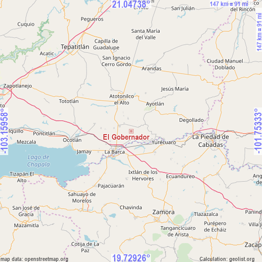
El Gobernador GPS coordinates[2]
20° 23' 23.028" North, 102° 27' 23.22" West
| Map corner | latitude | longitude |
|---|---|---|
| Upper-left | 21.04738°, | -103.15958° |
| Center: | 20.38973°, | -102.45645° |
| Lower-right: | 19.72926°, | -101.75333° |
| Map W x H: | 146.6×146.6 km | = 91.1×91.1mi |
| max Lat: | 32.7° ⇑34.6% North |
| El Gobernador: | 20.38973° |
| min Lat: | ⇓65.4% South 14.53588° |
| min Long | El Gobernador | max Long |
| -117.105° | -102.45645° | -86.73105° |
| W 16.2%⇐ | ⇒83.8% E |
Elevation
Elevation of El Gobernador is 1539 m = 5049 ft, and this is 285.3 m = 936 ft above average elevation for this country.
| Max E: |
3497 m = 11473 ft | 47.1% |
| El Gobernador | 1539 m 5049 ft | |
| Avg. | 1253.7 m = 4113 ft | |
Min E: |
-1 m = -3 ft | 52.9% |
See also: Mexico elevation on elevation.city.
Geographical zone
El Gobernador is located in North Torrid zone (between Equator and Tropic of Cancer). Distance of this Northern Tropic circle is 338.8 km =210.5 mi to North.| Distance of | km | miles | from El Gobernador |
|---|---|---|---|
| North Pole | 7739.9 | 4809.3 | to North |
| Arctic Circle | 5134 | 3190.1 | to North |
| Tropic Cancer | 338.8 | 210.5 | to North |
| Equator | 2267.1 | 1408.7 | to South |


Nearby cities:
15 places around El Gobernador: (largest is in red/bold)
• Cóndiro
9.9 km =6.2 mi,  280°
280°
• El Carmen
4.2 km =2.6 mi,  64°
64°
• El Cuenqueño
6.9 km =4.3 mi,  180°
180°
• El Loreto Occidental
5.5 km =3.4 mi,  195°
195°
• El Mirto
10 km =6.2 mi,  248°
248°
• La Paz de Ordaz
9.2 km =5.7 mi,  237°
237°
• Margaritas
7.3 km =4.5 mi,  345°
345°
• Portezuelo
7 km =4.3 mi,  291°
291°
• San Antonio de Rivas
5.3 km =3.3 mi,  145°
145°
• San José Casas Caídas
3.9 km =2.4 mi,  25°
25°
• San Ramón
3.9 km =2.4 mi, 179°
• Santa Elena
9.6 km =6 mi,  334°
334°
• Santa Lucía
9.3 km =5.8 mi,  107°
107°
• Santa Rita
9 km =5.6 mi,  50°
50°
• Villa de García Márquez
6.1 km =3.8 mi,  318°
318°
Sources, notices
• [Note1] Compared only with cities in Mexico existing in our database
• [Src1] Map data: © OpenStreetMap contributors (CC-BY-SA)
• [Src2] Other city data from geonames.org with taken over terms of usage.
• [Src3] Geographical zone / Annual Mean Temperature by Robert A. Rohde @ Wikipedia
