Buenavista geodata
Buenavista (Sinaloa) is a populated place; located in Mexico in America/Mazatlan (GMT-7) time zone. With population of 977 people, there are 8897 cities with bigger population in this country. Compared to other cities in Mexico, 92.6% of cities are located further ↓South; 96.4% of cities are located further →East and 95.7% of cities have higher elevation than Buenavista. Note1


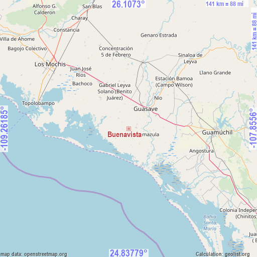
Buenavista GPS coordinates[2]
25° 28' 27.192" North, 108° 33' 31.392" West
| Map corner | latitude | longitude |
|---|---|---|
| Upper-left | 26.1073°, | -109.26185° |
| Center: | 25.47422°, | -108.55872° |
| Lower-right: | 24.83779°, | -107.8556° |
| Map W x H: | 141.2×141.2 km | = 87.7×87.7mi |
| max Lat: | 32.7° ⇑7.4% North |
| Buenavista: | 25.47422° |
| min Lat: | ⇓92.6% South 14.53588° |
| min Long | Buenavista | max Long |
| -117.105° | -108.55872° | -86.73105° |
| W 3.6%⇐ | ⇒96.4% E |
Elevation
Elevation of Buenavista is 12 m = 39 ft, and this is 1241.7 m = 4074 ft below average elevation for this country.
| Max E: |
3497 m = 11473 ft | 95.7% |
| Avg. | 1253.7 m = 4113 ft | |
| Buenavista | 12 m = 39 ft | |
Min E: |
-1 m = -3 ft | 4.3% |
See also: Mexico elevation on elevation.city.
Geographical zone
Buenavista is located in North temperate zone (between Tropic of Cancer and the Arctic Circle). Distance of this Northern Tropic circle is 226.5 km =140.7 mi to South.| Distance of | km | miles | from Buenavista |
|---|---|---|---|
| North Pole | 7174.6 | 4458.1 | to North |
| Arctic Circle | 4568.7 | 2838.9 | to North |
| Tropic Cancer | 226.5 | 140.7 | to South |
| Equator | 2832.5 | 1760 | to South |


Nearby cities:
15 places around Buenavista: (largest is in red/bold)
• Bebelama
6.9 km =4.3 mi,  87°
87°
• Buen Retiro (El Retiro)
8.2 km =5.1 mi,  99°
99°
• Chorohui
10.8 km =6.7 mi,  64°
64°
• El Progreso
5.8 km =3.6 mi,  214°
214°
• El Sacrificio
8.9 km =5.5 mi,  233°
233°
• La Chuparrosa
7.4 km =4.6 mi,  11°
11°
• La Sabanilla (Campo Preciado)
10.4 km =6.5 mi,  27°
27°
• Marcol
4.9 km =3 mi, 62°
• Roberto Barrios
8.2 km =5.1 mi,  315°
315°
• San Antonio
7.8 km =4.8 mi,  3°
3°
• San Fernando
10.7 km =6.6 mi,  331°
331°
• San Gabriel
10.4 km =6.5 mi,  53°
53°
• San Pedro Guasave
12.5 km =7.8 mi, 55°
• San Pedro Paredes
13.6 km =8.5 mi, 61°
• Tamazula
10.8 km =6.7 mi,  106°
106°
Sources, notices
• [Note1] Compared only with cities in Mexico existing in our database
• [Src1] Map data: © OpenStreetMap contributors (CC-BY-SA)
• [Src2] Other city data from geonames.org with taken over terms of usage.
• [Src3] Geographical zone / Annual Mean Temperature by Robert A. Rohde @ Wikipedia
