Boca Mismaloya geodata
Boca Mismaloya (Jalisco) is a populated place; located in Mexico in America/Mexico_City (GMT-6) time zone. With population of 743 people, there are 11779 cities with bigger population in this country. Compared to other cities in Mexico, 68.4% of cities are located further ↓South; 92.6% of cities are located further →East and 85.9% of cities have higher elevation than Boca Mismaloya. Note1


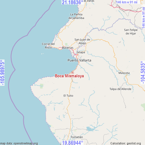
Boca Mismaloya GPS coordinates[2]
20° 31' 45.552" North, 105° 17' 11.832" West
| Map corner | latitude | longitude |
|---|---|---|
| Upper-left | 21.18636°, | -105.98975° |
| Center: | 20.52932°, | -105.28662° |
| Lower-right: | 19.86944°, | -104.5835° |
| Map W x H: | 146.4×146.4 km | = 91×91mi |
| max Lat: | 32.7° ⇑31.6% North |
| Boca Mismaloya: | 20.52932° |
| min Lat: | ⇓68.4% South 14.53588° |
| min Long | Boca Mismaloya | max Long |
| -117.105° | -105.28662° | -86.73105° |
| W 7.4%⇐ | ⇒92.6% E |
Elevation
Elevation of Boca Mismaloya is 39 m = 128 ft, and this is 1214.7 m = 3985 ft below average elevation for this country.
| Max E: |
3497 m = 11473 ft | 85.9% |
| Avg. | 1253.7 m = 4113 ft | |
| Boca Mismaloya | 39 m = 128 ft | |
Min E: |
-1 m = -3 ft | 14.1% |
See also: Mexico elevation on elevation.city.
Geographical zone
Boca Mismaloya is located in North Torrid zone (between Equator and Tropic of Cancer). Distance of this Northern Tropic circle is 323.3 km =200.9 mi to North.| Distance of | km | miles | from Boca Mismaloya |
|---|---|---|---|
| North Pole | 7724.4 | 4799.7 | to North |
| Arctic Circle | 5118.5 | 3180.5 | to North |
| Tropic Cancer | 323.3 | 200.9 | to North |
| Equator | 2282.6 | 1418.3 | to South |


Nearby cities:
15 places around Boca Mismaloya: (largest is in red/bold)
• Banus Vallarta (Verde Vallarta)
21.8 km =13.5 mi,  17°
17°
• Boca de Tomatlán
3.4 km =2.1 mi,  237°
237°
• El Tuito
23.6 km =14.7 mi,  189°
189°
• Ixtapa
22.5 km =14 mi, 22°
• Las Jarretaderas
18.2 km =11.3 mi,  4°
4°
• Las Juntas
19.6 km =12.2 mi,  12°
12°
• Las Juntas y los Veranos
5.5 km =3.4 mi, 188°
• Mezcales
22.4 km =13.9 mi, 1°
• Mezcalitos
20.4 km =12.7 mi, 1°
• Nuevo Vallarta
19.2 km =11.9 mi,  357°
357°
• Puerto Vallarta
11.4 km =7.1 mi,  31°
31°
• San Clemente de Lima
23.2 km =14.4 mi, 4°
• San Vicente
24.7 km =15.3 mi, 8°
• Tondoroque
24 km =14.9 mi, 358°
• Yelapa
17.4 km =10.8 mi,  254°
254°
Sources, notices
• [Note1] Compared only with cities in Mexico existing in our database
• [Src1] Map data: © OpenStreetMap contributors (CC-BY-SA)
• [Src2] Other city data from geonames.org with taken over terms of usage.
• [Src3] Geographical zone / Annual Mean Temperature by Robert A. Rohde @ Wikipedia
