Guadalupe de Atlas geodata
Guadalupe de Atlas (Aguascalientes) is a populated place; located in Mexico in America/Mexico_City (GMT-6) time zone. With population of 2,259 people, there are 3895 cities with bigger population in this country. Compared to other cities in Mexico, 85.6% of cities are located further ↓South; 81.2% of cities are located further →East and 74.6% of cities have lower elevation than Guadalupe de Atlas. Note1


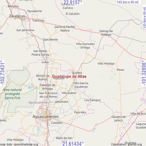
Guadalupe de Atlas GPS coordinates[2]
22° 15' 59.508" North, 102° 1' 52.248" West
| Map corner | latitude | longitude |
|---|---|---|
| Upper-left | 22.9157°, | -102.73431° |
| Center: | 22.26653°, | -102.03118° |
| Lower-right: | 21.61434°, | -101.32806° |
| Map W x H: | 144.7×144.7 km | = 89.9×89.9mi |
| max Lat: | 32.7° ⇑14.4% North |
| Guadalupe de Atlas: | 22.26653° |
| min Lat: | ⇓85.6% South 14.53588° |
| min Long | Guadalupe de At | max Long |
| -117.105° | -102.03118° | -86.73105° |
| W 18.8%⇐ | ⇒81.2% E |
Elevation
Elevation of Guadalupe de Atlas is 2023 m = 6637 ft, and this is 769.3 m = 2524 ft above average elevation for this country.
| Max E: |
3497 m = 11473 ft | 25.4% |
| Guadalupe de Atlas | 2023 m 6637 ft | |
| Avg. | 1253.7 m = 4113 ft | |
Min E: |
-1 m = -3 ft | 74.6% |
See also: Mexico elevation on elevation.city.
Geographical zone
Guadalupe de Atlas is located in North Torrid zone (between Equator and Tropic of Cancer). Distance of this Northern Tropic circle is 130.1 km =80.8 mi to North.| Distance of | km | miles | from Guadalupe de Atlas |
|---|---|---|---|
| North Pole | 7531.3 | 4679.7 | to North |
| Arctic Circle | 4925.4 | 3060.5 | to North |
| Tropic Cancer | 130.1 | 80.8 | to North |
| Equator | 2475.8 | 1538.4 | to South |


Nearby cities:
15 places around Guadalupe de Atlas: (largest is in red/bold)
• Asientos
6.8 km =4.2 mi,  242°
242°
• Bimbaletes
3.5 km =2.2 mi,  124°
124°
• Bimbaletes Aguascalientes (El Álamo)
3.8 km =2.4 mi,  160°
160°
• Bimbaletes Atlas
2.3 km =1.4 mi,  189°
189°
• Colonia Hidalgo (El Tecolote)
7 km =4.3 mi,  356°
356°
• Crisóstomos
5.5 km =3.4 mi,  138°
138°
• Ejido Hidalgo
3.9 km =2.4 mi,  348°
348°
• El Prieto
3.6 km =2.2 mi,  11°
11°
• Jarillas
4.7 km =2.9 mi,  314°
314°
• La Loma (El Bajío)
5 km =3.1 mi,  110°
110°
• Loreto
4.4 km =2.7 mi,  81°
81°
• Noria del Borrego (Norias)
2.6 km =1.6 mi,  334°
334°
• Norias de Guadalupe
2 km =1.2 mi, 79°
• Plutarco Elías Calles
6.1 km =3.8 mi,  199°
199°
• San Gil
6.6 km =4.1 mi,  171°
171°
Sources, notices
• [Note1] Compared only with cities in Mexico existing in our database
• [Src1] Map data: © OpenStreetMap contributors (CC-BY-SA)
• [Src2] Other city data from geonames.org with taken over terms of usage.
• [Src3] Geographical zone / Annual Mean Temperature by Robert A. Rohde @ Wikipedia
