Loreto geodata
Loreto (Zacatecas) is a seat of a second-order administrative division; located in Mexico in America/Mexico_City (GMT-6) time zone. With population of 24,260 people, there are 418 cities with bigger population in this country. Compared to other cities in Mexico, 85.6% of cities are located further ↓South; 80.9% of cities are located further →East and 75.1% of cities have lower elevation than Loreto. Note1


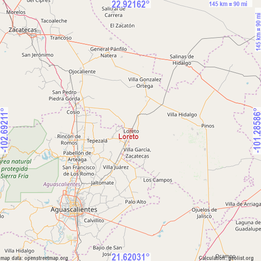
Loreto GPS coordinates[2]
22° 16' 20.928" North, 101° 59' 20.328" West
| Map corner | latitude | longitude |
|---|---|---|
| Upper-left | 22.92162°, | -102.69211° |
| Center: | 22.27248°, | -101.98898° |
| Lower-right: | 21.62031°, | -101.28586° |
| Map W x H: | 144.7×144.7 km | = 89.9×89.9mi |
| max Lat: | 32.7° ⇑14.4% North |
| Loreto: | 22.27248° |
| min Lat: | ⇓85.6% South 14.53588° |
| min Long | Loreto | max Long |
| -117.105° | -101.98898° | -86.73105° |
| W 19.1%⇐ | ⇒80.9% E |
Elevation
Elevation of Loreto is 2032 m = 6667 ft, and this is 778.3 m = 2553 ft above average elevation for this country.
| Max E: |
3497 m = 11473 ft | 24.9% |
| Loreto | 2032 m 6667 ft | |
| Avg. | 1253.7 m = 4113 ft | |
Min E: |
-1 m = -3 ft | 75.1% |
See also: Mexico elevation on elevation.city.
Geographical zone
Loreto is located in North Torrid zone (between Equator and Tropic of Cancer). Distance of this Northern Tropic circle is 129.5 km =80.5 mi to North.| Distance of | km | miles | from Loreto |
|---|---|---|---|
| North Pole | 7530.6 | 4679.3 | to North |
| Arctic Circle | 4924.7 | 3060.1 | to North |
| Tropic Cancer | 129.5 | 80.5 | to North |
| Equator | 2476.5 | 1538.8 | to South |


Nearby cities:
15 places around Loreto: (largest is in red/bold)
• Bimbaletes
3.1 km =1.9 mi,  208°
208°
• Bimbaletes Aguascalientes (El Álamo)
5.2 km =3.2 mi,  216°
216°
• Bimbaletes Atlas
5.6 km =3.5 mi,  237°
237°
• Colonia Hidalgo (El Tecolote)
8 km =5 mi,  322°
322°
• Crisóstomos
4.8 km =3 mi,  188°
188°
• Ejido Hidalgo
6 km =3.7 mi,  301°
301°
• El Prieto
4.6 km =2.9 mi,  307°
307°
• Guadalupe de Atlas
4.4 km =2.7 mi,  261°
261°
• Jarillas
8.1 km =5 mi,  288°
288°
• La Loma (El Bajío)
2.4 km =1.5 mi,  172°
172°
• Noria del Borrego (Norias)
5.7 km =3.5 mi, 286°
• Norias de Guadalupe
2.4 km =1.5 mi, 263°
• San Blas
4.6 km =2.9 mi,  49°
49°
• San Gil
8 km =5 mi, 205°
• San Marcos
3.8 km =2.4 mi,  81°
81°
Sources, notices
• [Note1] Compared only with cities in Mexico existing in our database
• [Src1] Map data: © OpenStreetMap contributors (CC-BY-SA)
• [Src2] Other city data from geonames.org with taken over terms of usage.
• [Src3] Geographical zone / Annual Mean Temperature by Robert A. Rohde @ Wikipedia
