Adjuntas del Monte geodata
Adjuntas del Monte (Guanajuato) is a populated place; located in Mexico in America/Mexico_City (GMT-6) time zone. With population of 987 people, there are 8822 cities with bigger population in this country. Compared to other cities in Mexico, 80.1% of cities are located further ↓South; 71.8% of cities are located further →East and 71.5% of cities have lower elevation than Adjuntas del Monte. Note1
Administrative division(s):
- Level 1: Guanajuato
- Level 2: Dolores Hidalgo Cuna de la Independencia Nacional


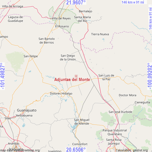
Adjuntas del Monte GPS coordinates[2]
21° 18' 25.596" North, 100° 47' 42.504" West
| Map corner | latitude | longitude |
|---|---|---|
| Upper-left | 21.9607°, | -101.49827° |
| Center: | 21.30711°, | -100.79514° |
| Lower-right: | 20.6506°, | -100.09202° |
| Map W x H: | 145.7×145.7 km | = 90.5×90.5mi |
| max Lat: | 32.7° ⇑19.9% North |
| Adjuntas del Monte: | 21.30711° |
| min Lat: | ⇓80.1% South 14.53588° |
| min Long | Adjuntas del Mo | max Long |
| -117.105° | -100.79514° | -86.73105° |
| W 28.2%⇐ | ⇒71.8% E |
Elevation
Elevation of Adjuntas del Monte is 1956 m = 6417 ft, and this is 702.3 m = 2304 ft above average elevation for this country.
| Max E: |
3497 m = 11473 ft | 28.5% |
| Adjuntas del Monte | 1956 m 6417 ft | |
| Avg. | 1253.7 m = 4113 ft | |
Min E: |
-1 m = -3 ft | 71.5% |
See also: Mexico elevation on elevation.city.
Geographical zone
Adjuntas del Monte is located in North Torrid zone (between Equator and Tropic of Cancer). Distance of this Northern Tropic circle is 236.8 km =147.1 mi to North.| Distance of | km | miles | from Adjuntas del Monte |
|---|---|---|---|
| North Pole | 7637.9 | 4746 | to North |
| Arctic Circle | 5032 | 3126.7 | to North |
| Tropic Cancer | 236.8 | 147.1 | to North |
| Equator | 2369.1 | 1472.1 | to South |


Nearby cities:
15 places around Adjuntas del Monte: (largest is in red/bold)
• Catalán del Refugio (Catalanes)
6.3 km =3.9 mi,  72°
72°
• Covadonga
11.6 km =7.2 mi,  113°
113°
• El Álamo
12 km =7.5 mi,  138°
138°
• Garabatillo
4.9 km =3 mi,  81°
81°
• La California
3.2 km =2 mi,  242°
242°
• La Colorada
6.4 km =4 mi,  258°
258°
• La Sabana
16.2 km =10.1 mi, 137°
• Las Yerbas
13.1 km =8.1 mi,  281°
281°
• Lourdes (Estación de Lourdes)
9.6 km =6 mi,  101°
101°
• Palma Prieta
10.6 km =6.6 mi,  121°
121°
• Peñuelas
8.9 km =5.5 mi,  3°
3°
• Pozo Blanco
15.4 km =9.6 mi, 100°
• Providencia
14 km =8.7 mi,  12°
12°
• San Antonio
15.8 km =9.8 mi,  317°
317°
• Soledad Nueva
13.5 km =8.4 mi, 256°
Sources, notices
• [Note1] Compared only with cities in Mexico existing in our database
• [Src1] Map data: © OpenStreetMap contributors (CC-BY-SA)
• [Src2] Other city data from geonames.org with taken over terms of usage.
• [Src3] Geographical zone / Annual Mean Temperature by Robert A. Rohde @ Wikipedia
