La Carroza geodata
La Carroza (Guanajuato) is a populated place; located in Mexico in America/Mexico_City (GMT-6) time zone. With population of 976 people, there are 8904 cities with bigger population in this country. Compared to other cities in Mexico, 69.2% of cities are located further ↓South; 78.1% of cities are located further →East and 58% of cities have lower elevation than La Carroza. Note1


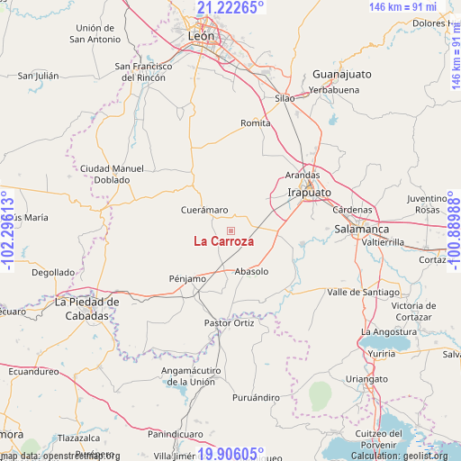
La Carroza GPS coordinates[2]
20° 33' 56.772" North, 101° 35' 34.8" West
| Map corner | latitude | longitude |
|---|---|---|
| Upper-left | 21.22265°, | -102.29613° |
| Center: | 20.56577°, | -101.593° |
| Lower-right: | 19.90605°, | -100.88988° |
| Map W x H: | 146.4×146.4 km | = 91×91mi |
| max Lat: | 32.7° ⇑30.8% North |
| La Carroza: | 20.56577° |
| min Lat: | ⇓69.2% South 14.53588° |
| min Long | La Carroza | max Long |
| -117.105° | -101.593° | -86.73105° |
| W 21.9%⇐ | ⇒78.1% E |
Elevation
Elevation of La Carroza is 1691 m = 5548 ft, and this is 437.3 m = 1435 ft above average elevation for this country.
| Max E: |
3497 m = 11473 ft | 42% |
| La Carroza | 1691 m 5548 ft | |
| Avg. | 1253.7 m = 4113 ft | |
Min E: |
-1 m = -3 ft | 58% |
See also: Mexico elevation on elevation.city.
Geographical zone
La Carroza is located in North Torrid zone (between Equator and Tropic of Cancer). Distance of this Northern Tropic circle is 319.2 km =198.3 mi to North.| Distance of | km | miles | from La Carroza |
|---|---|---|---|
| North Pole | 7720.4 | 4797.2 | to North |
| Arctic Circle | 5114.5 | 3178 | to North |
| Tropic Cancer | 319.2 | 198.3 | to North |
| Equator | 2286.7 | 1420.9 | to South |


Nearby cities:
15 places around La Carroza: (largest is in red/bold)
• Cerrito de Agua Caliente
7.9 km =4.9 mi,  5°
5°
• Colonia Hermosillo
6.9 km =4.3 mi,  78°
78°
• Corralejo de Hidalgo
7.7 km =4.8 mi,  210°
210°
• El Tule
4.4 km =2.7 mi,  186°
186°
• Estación Abasolo
7.1 km =4.4 mi,  163°
163°
• Estación Joaquín
7.6 km =4.7 mi,  94°
94°
• Galera de la Grulla
8.9 km =5.5 mi,  331°
331°
• Huitzatarito
8.5 km =5.3 mi, 164°
• Las Cruces
4.2 km =2.6 mi,  152°
152°
• Las Masas (La Luz Masas)
6.4 km =4 mi,  54°
54°
• San Francisco de Horta (El Alacrán)
4.2 km =2.6 mi,  74°
74°
• San Francisco de Horta (El Gato)
9.1 km =5.7 mi, 46°
• San Gregorio
4.2 km =2.6 mi,  240°
240°
• San Rafael de Horta
8.5 km =5.3 mi,  37°
37°
• Tupataro
6.4 km =4 mi,  300°
300°
Sources, notices
• [Note1] Compared only with cities in Mexico existing in our database
• [Src1] Map data: © OpenStreetMap contributors (CC-BY-SA)
• [Src2] Other city data from geonames.org with taken over terms of usage.
• [Src3] Geographical zone / Annual Mean Temperature by Robert A. Rohde @ Wikipedia
