Las Cruces geodata
Las Cruces (Guanajuato) is a populated place; located in Mexico in America/Mexico_City (GMT-6) time zone. With population of 531 people, there are 15939 cities with bigger population in this country. Compared to other cities in Mexico, 68.5% of cities are located further ↓South; 78% of cities are located further →East and 58.1% of cities have lower elevation than Las Cruces. Note1


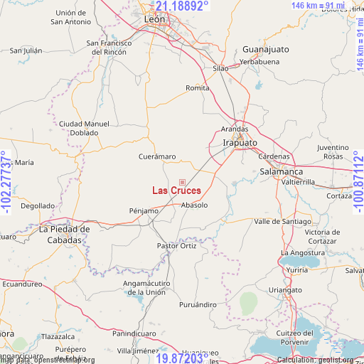
Las Cruces GPS coordinates[2]
20° 31' 54.804" North, 101° 34' 27.264" West
| Map corner | latitude | longitude |
|---|---|---|
| Upper-left | 21.18892°, | -102.27737° |
| Center: | 20.53189°, | -101.57424° |
| Lower-right: | 19.87203°, | -100.87112° |
| Map W x H: | 146.4×146.4 km | = 91×91mi |
| max Lat: | 32.7° ⇑31.5% North |
| Las Cruces: | 20.53189° |
| min Lat: | ⇓68.5% South 14.53588° |
| min Long | Las Cruces | max Long |
| -117.105° | -101.57424° | -86.73105° |
| W 22%⇐ | ⇒78% E |
Elevation
Elevation of Las Cruces is 1693 m = 5554 ft, and this is 439.3 m = 1441 ft above average elevation for this country.
| Max E: |
3497 m = 11473 ft | 41.9% |
| Las Cruces | 1693 m 5554 ft | |
| Avg. | 1253.7 m = 4113 ft | |
Min E: |
-1 m = -3 ft | 58.1% |
See also: Mexico elevation on elevation.city.
Geographical zone
Las Cruces is located in North Torrid zone (between Equator and Tropic of Cancer). Distance of this Northern Tropic circle is 323 km =200.7 mi to North.| Distance of | km | miles | from Las Cruces |
|---|---|---|---|
| North Pole | 7724.1 | 4799.5 | to North |
| Arctic Circle | 5118.2 | 3180.3 | to North |
| Tropic Cancer | 323 | 200.7 | to North |
| Equator | 2282.9 | 1418.5 | to South |


Nearby cities:
15 places around Las Cruces: (largest is in red/bold)
• Abasolo
10.2 km =6.3 mi,  153°
153°
• Colonia Hermosillo
7 km =4.3 mi,  42°
42°
• Corralejo de Hidalgo
6.5 km =4 mi,  243°
243°
• El Tule
2.5 km =1.6 mi,  256°
256°
• Estación Abasolo
3.1 km =1.9 mi,  178°
178°
• Estación Corralejo
8.2 km =5.1 mi,  212°
212°
• Estación Joaquín
6.5 km =4 mi,  60°
60°
• Huitzatarito
4.4 km =2.7 mi, 175°
• La Carroza
4.2 km =2.6 mi,  332°
332°
• Laguna Larga
9.4 km =5.8 mi,  83°
83°
• Las Masas (La Luz Masas)
8.2 km =5.1 mi,  23°
23°
• San Francisco de Horta (El Alacrán)
5.4 km =3.4 mi, 23°
• San Gregorio
5.9 km =3.7 mi,  286°
286°
• San José de González
6.3 km =3.9 mi,  119°
119°
• Tamazula
10.2 km =6.3 mi,  167°
167°
Sources, notices
• [Note1] Compared only with cities in Mexico existing in our database
• [Src1] Map data: © OpenStreetMap contributors (CC-BY-SA)
• [Src2] Other city data from geonames.org with taken over terms of usage.
• [Src3] Geographical zone / Annual Mean Temperature by Robert A. Rohde @ Wikipedia
