El Tlacuache geodata
El Tlacuache (Guanajuato) is a populated place; located in Mexico in America/Mexico_City (GMT-6) time zone. With population of 558 people, there are 15286 cities with bigger population in this country. Compared to other cities in Mexico, 64.1% of cities are located further ↓South; 79.3% of cities are located further →East and 60.4% of cities have lower elevation than El Tlacuache. Note1


El Tlacuache GPS coordinates[2]
20° 19' 49.152" North, 101° 44' 12.768" West
| Map corner | latitude | longitude |
|---|---|---|
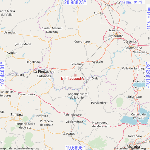
| Upper-left | 20.98823°, | -102.44001° |
| Center: | 20.33032°, | -101.73688° |
| Lower-right: | 19.6696°, | -101.03376° |
| Map W x H: | 146.6×146.6 km | = 91.1×91.1mi |
| max Lat: | 32.7° ⇑35.9% North |
| El Tlacuache: | 20.33032° |
| min Lat: | ⇓64.1% South 14.53588° |
| min Long | El Tlacuache | max Long |
| -117.105° | -101.73688° | -86.73105° |
| W 20.7%⇐ | ⇒79.3% E |
Elevation
Elevation of El Tlacuache is 1732 m = 5682 ft, and this is 478.3 m = 1569 ft above average elevation for this country.
| Max E: |
3497 m = 11473 ft | 39.6% |
| El Tlacuache | 1732 m 5682 ft | |
| Avg. | 1253.7 m = 4113 ft | |
Min E: |
-1 m = -3 ft | 60.4% |
See also: Mexico elevation on elevation.city.
Geographical zone
El Tlacuache is located in North Torrid zone (between Equator and Tropic of Cancer). Distance of this Northern Tropic circle is 345.4 km =214.6 mi to North.| Distance of | km | miles | from El Tlacuache |
|---|---|---|---|
| North Pole | 7746.5 | 4813.5 | to North |
| Arctic Circle | 5140.7 | 3194.3 | to North |
| Tropic Cancer | 345.4 | 214.6 | to North |
| Equator | 2260.5 | 1404.6 | to South |


Nearby cities:
15 places around El Tlacuache: (largest is in red/bold)
• Atarjea de Crucitas
9.8 km =6.1 mi,  100°
100°
• Churipitzeo
9.1 km =5.7 mi,  356°
356°
• Colorado de Saavedra
3.2 km =2 mi,  332°
332°
• El Pedregal de Arriba
8.4 km =5.2 mi,  22°
22°
• Estación Pénjamo
8.6 km =5.3 mi,  33°
33°
• La Troja (El Chiflido)
7.9 km =4.9 mi,  44°
44°
• Las Ánimas
9.9 km =6.2 mi,  318°
318°
• Noria de Barajas
7.3 km =4.5 mi,  84°
84°
• Ordeñita de Barajas
6.8 km =4.2 mi,  73°
73°
• Palo Alto de Abajo
8.4 km =5.2 mi,  299°
299°
• Rancho Seco de Barajas
6.2 km =3.9 mi,  54°
54°
• San Antonio de Aguirre (San Vicente)
3.7 km =2.3 mi, 17°
• Tacubaya
6.8 km =4.2 mi,  242°
242°
• Trojes de Paúl
3.5 km =2.2 mi,  254°
254°
• Zapote de Barajas
6.3 km =3.9 mi, 37°
Sources, notices
• [Note1] Compared only with cities in Mexico existing in our database
• [Src1] Map data: © OpenStreetMap contributors (CC-BY-SA)
• [Src2] Other city data from geonames.org with taken over terms of usage.
• [Src3] Geographical zone / Annual Mean Temperature by Robert A. Rohde @ Wikipedia
