La Enmarañada geodata
La Enmarañada (Guanajuato) is a populated place; located in Mexico in America/Mexico_City (GMT-6) time zone. With population of 588 people, there are 14598 cities with bigger population in this country. Compared to other cities in Mexico, 66% of cities are located further ↓South; 74.3% of cities are located further →East and 59.8% of cities have lower elevation than La Enmarañada. Note1


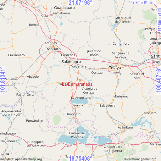
La Enmarañada GPS coordinates[2]
20° 24' 51.984" North, 101° 6' 37.008" West
| Map corner | latitude | longitude |
|---|---|---|
| Upper-left | 21.07198°, | -101.81341° |
| Center: | 20.41444°, | -101.11028° |
| Lower-right: | 19.75408°, | -100.40716° |
| Map W x H: | 146.5×146.5 km | = 91×91mi |
| max Lat: | 32.7° ⇑34% North |
| La Enmarañada: | 20.41444° |
| min Lat: | ⇓66% South 14.53588° |
| min Long | La Enmarañada | max Long |
| -117.105° | -101.11028° | -86.73105° |
| W 25.7%⇐ | ⇒74.3% E |
Elevation
Elevation of La Enmarañada is 1723 m = 5653 ft, and this is 469.3 m = 1540 ft above average elevation for this country.
| Max E: |
3497 m = 11473 ft | 40.2% |
| La Enmarañada | 1723 m 5653 ft | |
| Avg. | 1253.7 m = 4113 ft | |
Min E: |
-1 m = -3 ft | 59.8% |
See also: Mexico elevation on elevation.city.
Geographical zone
La Enmarañada is located in North Torrid zone (between Equator and Tropic of Cancer). Distance of this Northern Tropic circle is 336 km =208.8 mi to North.| Distance of | km | miles | from La Enmarañada |
|---|---|---|---|
| North Pole | 7737.2 | 4807.7 | to North |
| Arctic Circle | 5131.3 | 3188.4 | to North |
| Tropic Cancer | 336 | 208.8 | to North |
| Equator | 2269.9 | 1410.5 | to South |


Nearby cities:
15 places around La Enmarañada: (largest is in red/bold)
• Bella Vista de Santa María
5.9 km =3.7 mi,  190°
190°
• Colonia Morelos (El Chiquiador)
7.3 km =4.5 mi,  43°
43°
• El Molinito
4.3 km =2.7 mi,  69°
69°
• El Perico
7.1 km =4.4 mi,  202°
202°
• Hacienda de la Bolsa
4.4 km =2.7 mi,  171°
171°
• Jaral del Progreso
6.8 km =4.2 mi,  133°
133°
• La Compañía
6.5 km =4 mi,  230°
230°
• La Isla
3.9 km =2.4 mi,  3°
3°
• Los Llanitos (El Ranchito)
4.4 km =2.7 mi,  156°
156°
• Sabino de Santa Rosa
1 km =0.6 mi,  296°
296°
• San Bernardo
6.7 km =4.2 mi,  11°
11°
• San José de Araceo
7 km =4.3 mi, 234°
• San José del Cerrito de Camargo
7.1 km =4.4 mi,  85°
85°
• Santa Ana
4.6 km =2.9 mi,  182°
182°
• Sotelo
5.9 km =3.7 mi, 35°
Sources, notices
• [Note1] Compared only with cities in Mexico existing in our database
• [Src1] Map data: © OpenStreetMap contributors (CC-BY-SA)
• [Src2] Other city data from geonames.org with taken over terms of usage.
• [Src3] Geographical zone / Annual Mean Temperature by Robert A. Rohde @ Wikipedia
