El Perico geodata
El Perico (Guanajuato) is a populated place; located in Mexico in America/Mexico_City (GMT-6) time zone. With population of 990 people, there are 8795 cities with bigger population in this country. Compared to other cities in Mexico, 64.7% of cities are located further ↓South; 74.5% of cities are located further →East and 62.4% of cities have lower elevation than El Perico. Note1


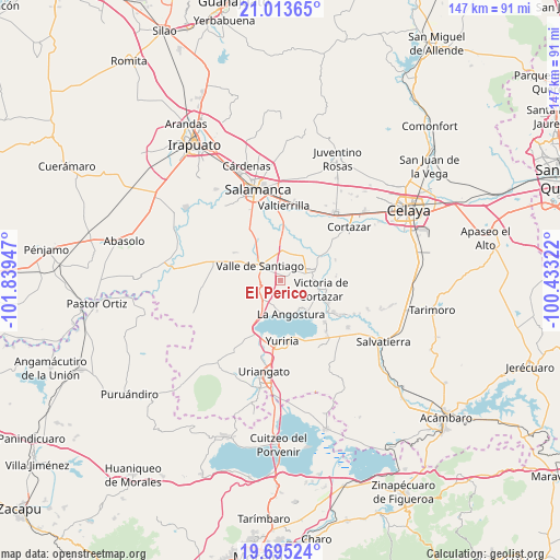
El Perico GPS coordinates[2]
20° 21' 21.06" North, 101° 8' 10.824" West
| Map corner | latitude | longitude |
|---|---|---|
| Upper-left | 21.01365°, | -101.83947° |
| Center: | 20.35585°, | -101.13634° |
| Lower-right: | 19.69524°, | -100.43322° |
| Map W x H: | 146.6×146.6 km | = 91.1×91.1mi |
| max Lat: | 32.7° ⇑35.3% North |
| El Perico: | 20.35585° |
| min Lat: | ⇓64.7% South 14.53588° |
| min Long | El Perico | max Long |
| -117.105° | -101.13634° | -86.73105° |
| W 25.5%⇐ | ⇒74.5% E |
Elevation
Elevation of El Perico is 1767 m = 5797 ft, and this is 513.3 m = 1684 ft above average elevation for this country.
| Max E: |
3497 m = 11473 ft | 37.6% |
| El Perico | 1767 m 5797 ft | |
| Avg. | 1253.7 m = 4113 ft | |
Min E: |
-1 m = -3 ft | 62.4% |
See also: Mexico elevation on elevation.city.
Geographical zone
El Perico is located in North Torrid zone (between Equator and Tropic of Cancer). Distance of this Northern Tropic circle is 342.6 km =212.9 mi to North.| Distance of | km | miles | from El Perico |
|---|---|---|---|
| North Pole | 7743.7 | 4811.7 | to North |
| Arctic Circle | 5137.8 | 3192.5 | to North |
| Tropic Cancer | 342.6 | 212.9 | to North |
| Equator | 2263.4 | 1406.4 | to South |


Nearby cities:
15 places around El Perico: (largest is in red/bold)
• Bella Vista de Santa María
1.8 km =1.1 mi,  65°
65°
• Crucitas
7.2 km =4.5 mi,  271°
271°
• Gervasio Mendoza
7.5 km =4.7 mi,  186°
186°
• Hacienda de la Bolsa
4 km =2.5 mi,  57°
57°
• La Compañía
3.3 km =2.1 mi,  316°
316°
• La Enmarañada
7.1 km =4.4 mi,  22°
22°
• Los Llanitos (El Ranchito)
5.1 km =3.2 mi, 60°
• Magdalena de Araceo
6.8 km =4.2 mi,  220°
220°
• Pozo de Aróstegui (Las Correas)
0.6 km =0.4 mi,  260°
260°
• Sabino de Santa Rosa
7.2 km =4.5 mi,  14°
14°
• San Jerónimo de Araceo
5.9 km =3.7 mi,  234°
234°
• San José de Araceo
3.9 km =2.4 mi,  309°
309°
• Santa Ana
3.1 km =1.9 mi,  52°
52°
• Valle de Santiago
7 km =4.3 mi,  304°
304°
• Zempoala
7.4 km =4.6 mi,  125°
125°
Sources, notices
• [Note1] Compared only with cities in Mexico existing in our database
• [Src1] Map data: © OpenStreetMap contributors (CC-BY-SA)
• [Src2] Other city data from geonames.org with taken over terms of usage.
• [Src3] Geographical zone / Annual Mean Temperature by Robert A. Rohde @ Wikipedia
