Arumbaro geodata
Arumbaro (Michoacán) is a populated place; located in Mexico in America/Mexico_City (GMT-6) time zone. With population of 626 people, there are 13818 cities with bigger population in this country. Compared to other cities in Mexico, 54.7% of cities are located further ↓South; 74.9% of cities are located further →East and 66.2% of cities have lower elevation than Arumbaro. Note1


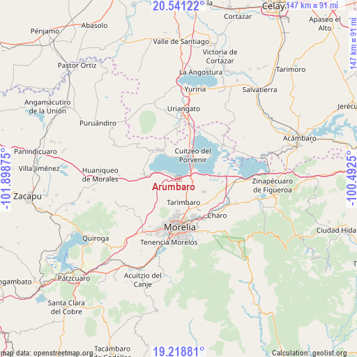
Arumbaro GPS coordinates[2]
19° 52' 53.004" North, 101° 11' 44.232" West
| Map corner | latitude | longitude |
|---|---|---|
| Upper-left | 20.54122°, | -101.89875° |
| Center: | 19.88139°, | -101.19562° |
| Lower-right: | 19.21881°, | -100.4925° |
| Map W x H: | 147×147 km | = 91.3×91.3mi |
| max Lat: | 32.7° ⇑45.3% North |
| Arumbaro: | 19.88139° |
| min Lat: | ⇓54.7% South 14.53588° |
| min Long | Arumbaro | max Long |
| -117.105° | -101.19562° | -86.73105° |
| W 25.1%⇐ | ⇒74.9% E |
Elevation
Elevation of Arumbaro is 1856 m = 6089 ft, and this is 602.3 m = 1976 ft above average elevation for this country.
| Max E: |
3497 m = 11473 ft | 33.8% |
| Arumbaro | 1856 m 6089 ft | |
| Avg. | 1253.7 m = 4113 ft | |
Min E: |
-1 m = -3 ft | 66.2% |
See also: Mexico elevation on elevation.city.
Geographical zone
Arumbaro is located in North Torrid zone (between Equator and Tropic of Cancer). Distance of this Northern Tropic circle is 395.3 km =245.6 mi to North.| Distance of | km | miles | from Arumbaro |
|---|---|---|---|
| North Pole | 7796.5 | 4844.5 | to North |
| Arctic Circle | 5190.6 | 3225.3 | to North |
| Tropic Cancer | 395.3 | 245.6 | to North |
| Equator | 2210.6 | 1373.6 | to South |


Nearby cities:
15 places around Arumbaro: (largest is in red/bold)
• Cañada de la Yerbabuena
2 km =1.2 mi,  218°
218°
• Cañada de los Sauces
5.9 km =3.7 mi,  201°
201°
• Cañada del Herrero
7 km =4.3 mi,  180°
180°
• Copándaro de Galeana
2.3 km =1.4 mi,  302°
302°
• Cuto del Porvenir
5.6 km =3.5 mi,  103°
103°
• Doctor Miguel Silva (San Guillermo)
9.7 km =6 mi,  13°
13°
• El Nispo
3.1 km =1.9 mi,  282°
282°
• Jamaica
7 km =4.3 mi,  114°
114°
• La Noria
9.3 km =5.8 mi,  118°
118°
• Mesón Nuevo (Cañada de la Magdalena)
8 km =5 mi,  157°
157°
• San Agustín del Maíz
3.8 km =2.4 mi,  58°
58°
• San Juan Benito Juárez (San Juan Tararameo)
8 km =5 mi, 60°
• Santa Cruz
5.1 km =3.2 mi,  127°
127°
• Santa Rita
7.4 km =4.6 mi,  290°
290°
• Tarímbaro
9.7 km =6 mi,  168°
168°
Sources, notices
• [Note1] Compared only with cities in Mexico existing in our database
• [Src1] Map data: © OpenStreetMap contributors (CC-BY-SA)
• [Src2] Other city data from geonames.org with taken over terms of usage.
• [Src3] Geographical zone / Annual Mean Temperature by Robert A. Rohde @ Wikipedia
