Capula geodata
Capula (Michoacán) is a populated place; located in Mexico in America/Mexico_City (GMT-6) time zone. With population of 5,086 people, there are 1821 cities with bigger population in this country. Compared to other cities in Mexico, 50.3% of cities are located further ↑North; 76.4% of cities are located further →East and 78.4% of cities have lower elevation than Capula. Note1


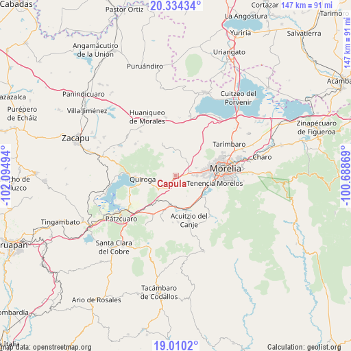
Capula GPS coordinates[2]
19° 40' 25.104" North, 101° 23' 30.516" West
| Map corner | latitude | longitude |
|---|---|---|
| Upper-left | 20.33434°, | -102.09494° |
| Center: | 19.67364°, | -101.39181° |
| Lower-right: | 19.0102°, | -100.68869° |
| Map W x H: | 147.2×147.2 km | = 91.5×91.5mi |
| max Lat: | 32.7° ⇑50.3% North |
| Capula: | 19.67364° |
| min Lat: | ⇓49.7% South 14.53588° |
| min Long | Capula | max Long |
| -117.105° | -101.39181° | -86.73105° |
| W 23.6%⇐ | ⇒76.4% E |
Elevation
Elevation of Capula is 2098 m = 6883 ft, and this is 844.3 m = 2770 ft above average elevation for this country.
| Max E: |
3497 m = 11473 ft | 21.6% |
| Capula | 2098 m 6883 ft | |
| Avg. | 1253.7 m = 4113 ft | |
Min E: |
-1 m = -3 ft | 78.4% |
See also: Mexico elevation on elevation.city.
Geographical zone
Capula is located in North Torrid zone (between Equator and Tropic of Cancer). Distance of this Northern Tropic circle is 418.4 km =260 mi to North.| Distance of | km | miles | from Capula |
|---|---|---|---|
| North Pole | 7819.6 | 4858.9 | to North |
| Arctic Circle | 5213.7 | 3239.6 | to North |
| Tropic Cancer | 418.4 | 260 | to North |
| Equator | 2187.5 | 1359.2 | to South |


Nearby cities:
15 places around Capula: (largest is in red/bold)
• Conjunto Habitacional Villas del Pedregal
9.3 km =5.8 mi,  83°
83°
• Cuto de la Esperanza
8.3 km =5.2 mi,  40°
40°
• El Cerrito Itzícuaro
11.8 km =7.3 mi,  91°
91°
• El Correo
5.6 km =3.5 mi,  209°
209°
• Fontezuelas
11.8 km =7.3 mi, 212°
• Iratzio
3.7 km =2.3 mi, 214°
• La Caja
10.6 km =6.6 mi,  204°
204°
• La Concepción
9.1 km =5.7 mi,  67°
67°
• Lomas de la Maestranza
6.6 km =4.1 mi, 76°
• San Antonio Parangare
10.8 km =6.7 mi,  106°
106°
• San Lorenzo Itzícuaro
11.6 km =7.2 mi, 88°
• San Nicolás Obispo
8.3 km =5.2 mi, 106°
• Tacicuaro
3.4 km =2.1 mi,  97°
97°
• Villa Magna
6.9 km =4.3 mi, 80°
• Villas de la Loma
9.8 km =6.1 mi, 79°
Sources, notices
• [Note1] Compared only with cities in Mexico existing in our database
• [Src1] Map data: © OpenStreetMap contributors (CC-BY-SA)
• [Src2] Other city data from geonames.org with taken over terms of usage.
• [Src3] Geographical zone / Annual Mean Temperature by Robert A. Rohde @ Wikipedia
