Iratzio geodata
Iratzio (Michoacán) is a populated place; located in Mexico in America/Mexico_City (GMT-6) time zone. With population of 1,003 people, there are 8693 cities with bigger population in this country. Compared to other cities in Mexico, 51% of cities are located further ↑North; 76.6% of cities are located further →East and 83.6% of cities have lower elevation than Iratzio. Note1


Iratzio GPS coordinates[2]
19° 38' 44.988" North, 101° 24' 42.984" West
| Map corner | latitude | longitude |
|---|---|---|
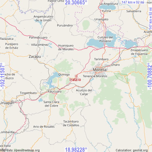
| Upper-left | 20.30665°, | -102.11507° |
| Center: | 19.64583°, | -101.41194° |
| Lower-right: | 18.98228°, | -100.70882° |
| Map W x H: | 147.3×147.3 km | = 91.5×91.5mi |
| max Lat: | 32.7° ⇑51% North |
| Iratzio: | 19.64583° |
| min Lat: | ⇓49% South 14.53588° |
| min Long | Iratzio | max Long |
| -117.105° | -101.41194° | -86.73105° |
| W 23.4%⇐ | ⇒76.6% E |
Elevation
Elevation of Iratzio is 2234 m = 7329 ft, and this is 980.3 m = 3216 ft above average elevation for this country.
| Max E: |
3497 m = 11473 ft | 16.4% |
| Iratzio | 2234 m 7329 ft | |
| Avg. | 1253.7 m = 4113 ft | |
Min E: |
-1 m = -3 ft | 83.6% |
See also: Mexico elevation on elevation.city.
Geographical zone
Iratzio is located in North Torrid zone (between Equator and Tropic of Cancer). Distance of this Northern Tropic circle is 421.5 km =261.9 mi to North.| Distance of | km | miles | from Iratzio |
|---|---|---|---|
| North Pole | 7822.7 | 4860.8 | to North |
| Arctic Circle | 5216.8 | 3241.6 | to North |
| Tropic Cancer | 421.5 | 261.9 | to North |
| Equator | 2184.4 | 1357.3 | to South |


Nearby cities:
15 places around Iratzio: (largest is in red/bold)
• Capula
3.7 km =2.3 mi,  34°
34°
• Conjunto Habitacional Villas del Pedregal
12.1 km =7.5 mi,  69°
69°
• Cuto de la Esperanza
12.1 km =7.5 mi,  38°
38°
• El Correo
1.9 km =1.2 mi,  200°
200°
• Fontezuelas
8.1 km =5 mi,  211°
211°
• Huiramba
11.4 km =7.1 mi,  193°
193°
• La Caja
6.9 km =4.3 mi, 198°
• La Concepción
12.4 km =7.7 mi,  58°
58°
• Lagunillas
9.3 km =5.8 mi,  182°
182°
• Lomas de la Maestranza
9.7 km =6 mi, 61°
• Quiroga
11.8 km =7.3 mi,  280°
280°
• San José Coapa
10.2 km =6.3 mi,  164°
164°
• San Nicolás Obispo
10.1 km =6.3 mi,  85°
85°
• Tacicuaro
6.1 km =3.8 mi, 64°
• Villa Magna
9.9 km =6.2 mi, 64°
Sources, notices
• [Note1] Compared only with cities in Mexico existing in our database
• [Src1] Map data: © OpenStreetMap contributors (CC-BY-SA)
• [Src2] Other city data from geonames.org with taken over terms of usage.
• [Src3] Geographical zone / Annual Mean Temperature by Robert A. Rohde @ Wikipedia
