Los Coyotes geodata
Los Coyotes (Michoacán) is a populated place; located in Mexico in America/Mexico_City (GMT-6) time zone. With population of 522 people, there are 16162 cities with bigger population in this country. Compared to other cities in Mexico, 77.3% of cities are located further ↑North; 82.6% of cities are located further →East and 75.7% of cities have higher elevation than Los Coyotes. Note1


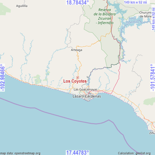
Los Coyotes GPS coordinates[2]
18° 7' 2.496" North, 102° 16' 53.508" West
| Map corner | latitude | longitude |
|---|---|---|
| Upper-left | 18.78434°, | -102.98466° |
| Center: | 18.11736°, | -102.28153° |
| Lower-right: | 17.44783°, | -101.57841° |
| Map W x H: | 148.6×148.6 km | = 92.3×92.3mi |
| max Lat: | 32.7° ⇑77.3% North |
| Los Coyotes: | 18.11736° |
| min Lat: | ⇓22.7% South 14.53588° |
| min Long | Los Coyotes | max Long |
| -117.105° | -102.28153° | -86.73105° |
| W 17.4%⇐ | ⇒82.6% E |
Elevation
Elevation of Los Coyotes is 200 m = 656 ft, and this is 1053.7 m = 3457 ft below average elevation for this country.
| Max E: |
3497 m = 11473 ft | 75.7% |
| Avg. | 1253.7 m = 4113 ft | |
| Los Coyotes | 200 m = 656 ft | |
Min E: |
-1 m = -3 ft | 24.3% |
See also: Mexico elevation on elevation.city.
Geographical zone
Los Coyotes is located in North Torrid zone (between Equator and Tropic of Cancer). Distance of this Northern Tropic circle is 591.5 km =367.5 mi to North.| Distance of | km | miles | from Los Coyotes |
|---|---|---|---|
| North Pole | 7992.6 | 4966.4 | to North |
| Arctic Circle | 5386.7 | 3347.1 | to North |
| Tropic Cancer | 591.5 | 367.5 | to North |
| Equator | 2014.5 | 1251.8 | to South |


Nearby cities:
15 places around Los Coyotes: (largest is in red/bold)
• Acalpican de Morelos
12.6 km =7.8 mi,  209°
209°
• Buenos Aires
10.3 km =6.4 mi,  182°
182°
• Chucutitán
22.2 km =13.8 mi,  242°
242°
• Ciudad Lázaro Cárdenas
17.5 km =10.9 mi,  158°
158°
• El Bordonal
12.8 km =8 mi,  194°
194°
• El Habillal
15.6 km =9.7 mi,  218°
218°
• El Naranjito
19.5 km =12.1 mi,  137°
137°
• Guacamayas
13.1 km =8.1 mi,  146°
146°
• La Mira
10.4 km =6.5 mi, 206°
• La Orilla
14.7 km =9.1 mi, 156°
• Playa Azul
16.6 km =10.3 mi,  204°
204°
• Puente de la Vía
12.6 km =7.8 mi,  165°
165°
• San Francisco
22.5 km =14 mi,  134°
134°
• Tamacuas (El Ranchito)
14.4 km =8.9 mi, 130°
• Zacatula
16.1 km =10 mi, 137°
Sources, notices
• [Note1] Compared only with cities in Mexico existing in our database
• [Src1] Map data: © OpenStreetMap contributors (CC-BY-SA)
• [Src2] Other city data from geonames.org with taken over terms of usage.
• [Src3] Geographical zone / Annual Mean Temperature by Robert A. Rohde @ Wikipedia
