Guayameo geodata
Guayameo (Guerrero) is a populated place; located in Mexico in America/Mexico_City (GMT-6) time zone. With population of 1,627 people, there are 5320 cities with bigger population in this country. Compared to other cities in Mexico, 74.8% of cities are located further ↑North; 75.3% of cities are located further →East and 65.8% of cities have higher elevation than Guayameo. Note1


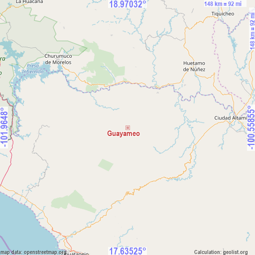
Guayameo GPS coordinates[2]
18° 18' 14.652" North, 101° 15' 42.012" West
| Map corner | latitude | longitude |
|---|---|---|
| Upper-left | 18.97032°, | -101.9648° |
| Center: | 18.30407°, | -101.26167° |
| Lower-right: | 17.63525°, | -100.55855° |
| Map W x H: | 148.4×148.4 km | = 92.2×92.2mi |
| max Lat: | 32.7° ⇑74.8% North |
| Guayameo: | 18.30407° |
| min Lat: | ⇓25.2% South 14.53588° |
| min Long | Guayameo | max Long |
| -117.105° | -101.26167° | -86.73105° |
| W 24.7%⇐ | ⇒75.3% E |
Elevation
Elevation of Guayameo is 642 m = 2106 ft, and this is 611.7 m = 2007 ft below average elevation for this country.
| Max E: |
3497 m = 11473 ft | 65.8% |
| Avg. | 1253.7 m = 4113 ft | |
| Guayameo | 642 m = 2106 ft | |
Min E: |
-1 m = -3 ft | 34.2% |
See also: Mexico elevation on elevation.city.
Geographical zone
Guayameo is located in North Torrid zone (between Equator and Tropic of Cancer). Distance of this Northern Tropic circle is 570.7 km =354.6 mi to North.| Distance of | km | miles | from Guayameo |
|---|---|---|---|
| North Pole | 7971.8 | 4953.4 | to North |
| Arctic Circle | 5366 | 3334.3 | to North |
| Tropic Cancer | 570.7 | 354.6 | to North |
| Equator | 2035.2 | 1264.6 | to South |


Nearby cities:
15 places around Guayameo: (largest is in red/bold)
• Aratichanguío
22.1 km =13.7 mi,  331°
331°
• Arroyo Grande
40 km =24.9 mi,  84°
84°
• Capeo
34.4 km =21.4 mi,  42°
42°
• Comburindio
41.1 km =25.5 mi,  48°
48°
• El Naranjo
40.2 km =25 mi, 81°
• La Calera
30.2 km =18.8 mi,  63°
63°
• Paso de Arena
43.8 km =27.2 mi,  90°
90°
• Patambó
41.9 km =26 mi,  102°
102°
• Pineda
42.8 km =26.6 mi, 92°
• Placeres del Oro
38.7 km =24 mi, 101°
• San Jerónimo
26.4 km =16.4 mi,  344°
344°
• Santa Teresa
46.7 km =29 mi, 84°
• Turitzio
41.5 km =25.8 mi, 53°
• Vallecitos de Zaragoza
43.2 km =26.8 mi,  188°
188°
• Zirándaro de los Chávez
35.4 km =22 mi, 57°
Sources, notices
• [Note1] Compared only with cities in Mexico existing in our database
• [Src1] Map data: © OpenStreetMap contributors (CC-BY-SA)
• [Src2] Other city data from geonames.org with taken over terms of usage.
• [Src3] Geographical zone / Annual Mean Temperature by Robert A. Rohde @ Wikipedia
