Aratichanguío geodata
Aratichanguío (Guerrero) is a populated place; located in Mexico in America/Mexico_City (GMT-6) time zone. With population of 1,401 people, there are 6179 cities with bigger population in this country. Compared to other cities in Mexico, 72.9% of cities are located further ↑North; 76.1% of cities are located further →East and 75.2% of cities have higher elevation than Aratichanguío. Note1


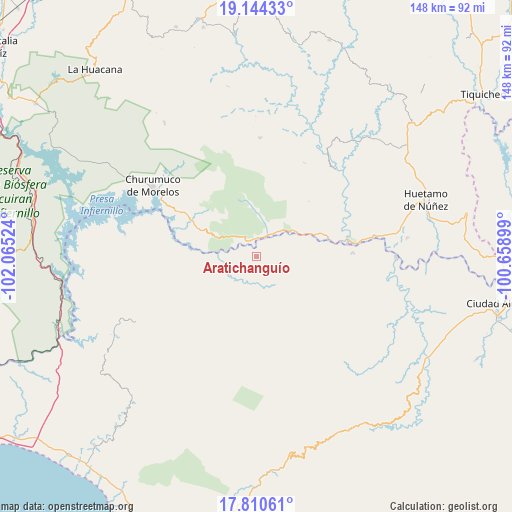
Aratichanguío GPS coordinates[2]
18° 28' 43.572" North, 101° 21' 43.596" West
| Map corner | latitude | longitude |
|---|---|---|
| Upper-left | 19.14433°, | -102.06524° |
| Center: | 18.47877°, | -101.36211° |
| Lower-right: | 17.81061°, | -100.65899° |
| Map W x H: | 148.3×148.3 km | = 92.1×92.1mi |
| max Lat: | 32.7° ⇑72.9% North |
| Aratichanguío: | 18.47877° |
| min Lat: | ⇓27.1% South 14.53588° |
| min Long | Aratichanguío | max Long |
| -117.105° | -101.36211° | -86.73105° |
| W 23.9%⇐ | ⇒76.1% E |
Elevation
Elevation of Aratichanguío is 216 m = 709 ft, and this is 1037.7 m = 3405 ft below average elevation for this country.
| Max E: |
3497 m = 11473 ft | 75.2% |
| Avg. | 1253.7 m = 4113 ft | |
| Aratichanguío | 216 m = 709 ft | |
Min E: |
-1 m = -3 ft | 24.8% |
See also: Mexico elevation on elevation.city.
Geographical zone
Aratichanguío is located in North Torrid zone (between Equator and Tropic of Cancer). Distance of this Northern Tropic circle is 551.3 km =342.6 mi to North.| Distance of | km | miles | from Aratichanguío |
|---|---|---|---|
| North Pole | 7952.4 | 4941.4 | to North |
| Arctic Circle | 5346.5 | 3322.2 | to North |
| Tropic Cancer | 551.3 | 342.6 | to North |
| Equator | 2054.6 | 1276.7 | to South |


Nearby cities:
15 places around Aratichanguío: (largest is in red/bold)
• Capeo
34.5 km =21.4 mi,  80°
80°
• Churumuco de Morelos
36.4 km =22.6 mi,  304°
304°
• Coahuayutla de Guerrero
43.4 km =27 mi,  245°
245°
• Comburindio
42.1 km =26.2 mi, 79°
• El Naranjo
52.1 km =32.4 mi,  105°
105°
• El Timbiriche
25.6 km =15.9 mi,  322°
322°
• Guayameo
22.1 km =13.7 mi,  151°
151°
• Huetamo de Núñez
51.8 km =32.2 mi,  71°
71°
• La Calera
38.2 km =23.7 mi,  99°
99°
• Palma de Huaro
49.1 km =30.5 mi, 304°
• Poturo
46.8 km =29.1 mi,  325°
325°
• Purechucho
51.2 km =31.8 mi, 77°
• San Jerónimo
7.1 km =4.4 mi,  31°
31°
• Turitzio
44.1 km =27.4 mi, 83°
• Zirándaro de los Chávez
40.4 km =25.1 mi,  90°
90°
Sources, notices
• [Note1] Compared only with cities in Mexico existing in our database
• [Src1] Map data: © OpenStreetMap contributors (CC-BY-SA)
• [Src2] Other city data from geonames.org with taken over terms of usage.
• [Src3] Geographical zone / Annual Mean Temperature by Robert A. Rohde @ Wikipedia
