Corral Falso geodata
Corral Falso (Guerrero) is a populated place; located in Mexico in America/Mexico_City (GMT-6) time zone. With population of 1,322 people, there are 6565 cities with bigger population in this country. Compared to other cities in Mexico, 86.8% of cities are located further ↑North; 69.1% of cities are located further →East and 89.4% of cities have higher elevation than Corral Falso. Note1


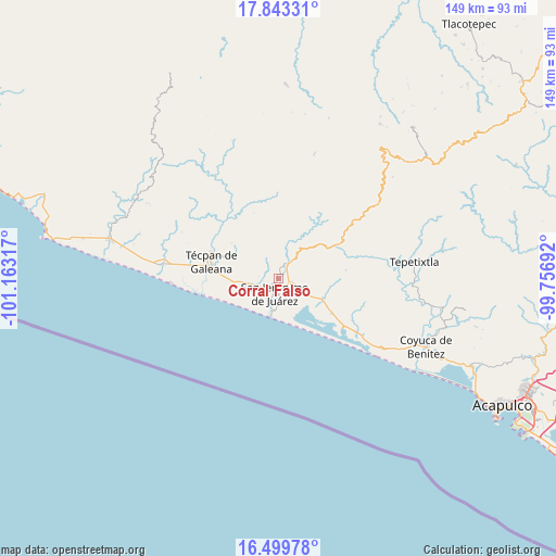
Corral Falso GPS coordinates[2]
17° 10' 21.936" North, 100° 27' 36.144" West
| Map corner | latitude | longitude |
|---|---|---|
| Upper-left | 17.84331°, | -101.16317° |
| Center: | 17.17276°, | -100.46004° |
| Lower-right: | 16.49978°, | -99.75692° |
| Map W x H: | 149.4×149.4 km | = 92.8×92.8mi |
| max Lat: | 32.7° ⇑86.8% North |
| Corral Falso: | 17.17276° |
| min Lat: | ⇓13.2% South 14.53588° |
| min Long | Corral Falso | max Long |
| -117.105° | -100.46004° | -86.73105° |
| W 30.9%⇐ | ⇒69.1% E |
Elevation
Elevation of Corral Falso is 26 m = 85 ft, and this is 1227.7 m = 4028 ft below average elevation for this country.
| Max E: |
3497 m = 11473 ft | 89.4% |
| Avg. | 1253.7 m = 4113 ft | |
| Corral Falso | 26 m = 85 ft | |
Min E: |
-1 m = -3 ft | 10.6% |
See also: Mexico elevation on elevation.city.
Geographical zone
Corral Falso is located in North Torrid zone (between Equator and Tropic of Cancer). Distance of this Northern Tropic circle is 696.5 km =432.8 mi to North.| Distance of | km | miles | from Corral Falso |
|---|---|---|---|
| North Pole | 8097.6 | 5031.6 | to North |
| Arctic Circle | 5491.7 | 3412.4 | to North |
| Tropic Cancer | 696.5 | 432.8 | to North |
| Equator | 1909.4 | 1186.4 | to South |


Nearby cities:
15 places around Corral Falso: (largest is in red/bold)
• Alcholoa
6 km =3.7 mi,  113°
113°
• Arenal de Gómez (Primer Arenal)
3.7 km =2.3 mi,  176°
176°
• Arenal de Álvarez (Arenal de Paco)
5.2 km =3.2 mi,  174°
174°
• Arenal del Centro (La Máquina)
4.4 km =2.7 mi, 179°
• Atoyac de Álvarez
4.7 km =2.9 mi,  37°
37°
• Cacalutla
12.8 km =8 mi, 114°
• Colonia 2 de Diciembre de 1974
3.6 km =2.2 mi,  89°
89°
• Colonia Buenos Aires
5.2 km =3.2 mi, 110°
• El Ciruelar
3.4 km =2.1 mi,  99°
99°
• El Ticui
5.1 km =3.2 mi,  18°
18°
• Hacienda de Cabañas
8.5 km =5.3 mi,  188°
188°
• La Y Griega
2.9 km =1.8 mi, 106°
• Las Tunas
6.4 km =4 mi,  202°
202°
• San Jerónimo de Juárez
3.9 km =2.4 mi, 196°
• Santa María
13.4 km =8.3 mi,  298°
298°
Sources, notices
• [Note1] Compared only with cities in Mexico existing in our database
• [Src1] Map data: © OpenStreetMap contributors (CC-BY-SA)
• [Src2] Other city data from geonames.org with taken over terms of usage.
• [Src3] Geographical zone / Annual Mean Temperature by Robert A. Rohde @ Wikipedia
