Cacalutla geodata
Cacalutla (Guerrero) is a populated place; located in Mexico in America/Mexico_City (GMT-6) time zone. With population of 2,010 people, there are 4326 cities with bigger population in this country. Compared to other cities in Mexico, 87.4% of cities are located further ↑North; 67.9% of cities are located further →East and 86.3% of cities have higher elevation than Cacalutla. Note1


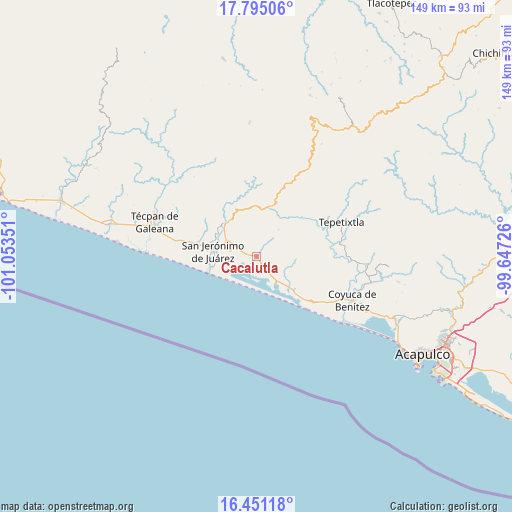
Cacalutla GPS coordinates[2]
17° 7' 27.588" North, 100° 21' 1.368" West
| Map corner | latitude | longitude |
|---|---|---|
| Upper-left | 17.79506°, | -101.05351° |
| Center: | 17.12433°, | -100.35038° |
| Lower-right: | 16.45118°, | -99.64726° |
| Map W x H: | 149.4×149.4 km | = 92.8×92.8mi |
| max Lat: | 32.7° ⇑87.4% North |
| Cacalutla: | 17.12433° |
| min Lat: | ⇓12.6% South 14.53588° |
| min Long | Cacalutla | max Long |
| -117.105° | -100.35038° | -86.73105° |
| W 32.1%⇐ | ⇒67.9% E |
Elevation
Elevation of Cacalutla is 37 m = 121 ft, and this is 1216.7 m = 3992 ft below average elevation for this country.
| Max E: |
3497 m = 11473 ft | 86.3% |
| Avg. | 1253.7 m = 4113 ft | |
| Cacalutla | 37 m = 121 ft | |
Min E: |
-1 m = -3 ft | 13.7% |
See also: Mexico elevation on elevation.city.
Geographical zone
Cacalutla is located in North Torrid zone (between Equator and Tropic of Cancer). Distance of this Northern Tropic circle is 701.9 km =436.1 mi to North.| Distance of | km | miles | from Cacalutla |
|---|---|---|---|
| North Pole | 8103 | 5035 | to North |
| Arctic Circle | 5497.1 | 3415.7 | to North |
| Tropic Cancer | 701.9 | 436.1 | to North |
| Equator | 1904 | 1183.1 | to South |


Nearby cities:
15 places around Cacalutla: (largest is in red/bold)
• Alcholoa
6.8 km =4.2 mi,  295°
295°
• Arenal de Gómez (Primer Arenal)
11.5 km =7.1 mi,  278°
278°
• Arenal de Álvarez (Arenal de Paco)
11.1 km =6.9 mi,  271°
271°
• Arenal del Centro (La Máquina)
11.6 km =7.2 mi, 275°
• Atoyac de Álvarez
12.7 km =7.9 mi,  316°
316°
• Cayaco
12.2 km =7.6 mi,  134°
134°
• Colonia 2 de Diciembre de 1974
9.7 km =6 mi, 304°
• Colonia Buenos Aires
7.7 km =4.8 mi, 297°
• Colonia Cuauhtémoc
2.8 km =1.7 mi,  146°
146°
• Corral Falso
12.8 km =8 mi,  294°
294°
• El Ciruelar
9.6 km =6 mi, 300°
• El Quemado
10 km =6.2 mi,  39°
39°
• La Y Griega
9.9 km =6.2 mi, 297°
• San Jerónimo de Juárez
12.9 km =8 mi, 277°
• Zacualpan
4.7 km =2.9 mi, 146°
Sources, notices
• [Note1] Compared only with cities in Mexico existing in our database
• [Src1] Map data: © OpenStreetMap contributors (CC-BY-SA)
• [Src2] Other city data from geonames.org with taken over terms of usage.
• [Src3] Geographical zone / Annual Mean Temperature by Robert A. Rohde @ Wikipedia
