El Paraíso geodata
El Paraíso (Guerrero) is a populated place; located in Mexico in America/Mexico_City (GMT-6) time zone. With population of 3,656 people, there are 2508 cities with bigger population in this country. Compared to other cities in Mexico, 84.8% of cities are located further ↑North; 66.7% of cities are located further →East and 63.4% of cities have higher elevation than El Paraíso. Note1


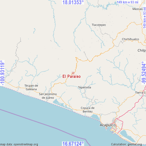
El Paraíso GPS coordinates[2]
17° 20' 36.996" North, 100° 13' 41.016" West
| Map corner | latitude | longitude |
|---|---|---|
| Upper-left | 18.01353°, | -100.93119° |
| Center: | 17.34361°, | -100.22806° |
| Lower-right: | 16.67124°, | -99.52494° |
| Map W x H: | 149.2×149.3 km | = 92.7×92.8mi |
| max Lat: | 32.7° ⇑84.8% North |
| El Paraíso: | 17.34361° |
| min Lat: | ⇓15.2% South 14.53588° |
| min Long | El Paraíso | max Long |
| -117.105° | -100.22806° | -86.73105° |
| W 33.3%⇐ | ⇒66.7% E |
Elevation
Elevation of El Paraíso is 792 m = 2598 ft, and this is 461.7 m = 1515 ft below average elevation for this country.
| Max E: |
3497 m = 11473 ft | 63.4% |
| Avg. | 1253.7 m = 4113 ft | |
| El Paraíso | 792 m = 2598 ft | |
Min E: |
-1 m = -3 ft | 36.6% |
See also: Mexico elevation on elevation.city.
Geographical zone
El Paraíso is located in North Torrid zone (between Equator and Tropic of Cancer). Distance of this Northern Tropic circle is 677.5 km =421 mi to North.| Distance of | km | miles | from El Paraíso |
|---|---|---|---|
| North Pole | 8078.6 | 5019.8 | to North |
| Arctic Circle | 5472.7 | 3400.6 | to North |
| Tropic Cancer | 677.5 | 421 | to North |
| Equator | 1928.4 | 1198.3 | to South |


Nearby cities:
15 places around El Paraíso: (largest is in red/bold)
• Atoyac de Álvarez
26.6 km =16.5 mi,  235°
235°
• Barrio Nuevo del Progreso
21.3 km =13.2 mi,  128°
128°
• Campo Morado
27 km =16.8 mi,  10°
10°
• El Edén
10.3 km =6.4 mi,  67°
67°
• El Quemado
17.9 km =11.1 mi,  201°
201°
• La Pintada
6.3 km =3.9 mi,  87°
87°
• Pié de la Cuesta
20.9 km =13 mi,  314°
314°
• Pueblo Viejo
24.6 km =15.3 mi,  28°
28°
• Río Santiago
13.8 km =8.6 mi,  223°
223°
• San Andrés de la Cruz
17 km =10.6 mi, 235°
• San Juan de las Flores
18.2 km =11.3 mi,  260°
260°
• San Vicente de Jesús
8.6 km =5.3 mi,  211°
211°
• Santiago de la Unión
16 km =9.9 mi,  228°
228°
• Santo Domingo
18 km =11.2 mi, 312°
• Tepetixtla
18.5 km =11.5 mi,  140°
140°
Sources, notices
• [Note1] Compared only with cities in Mexico existing in our database
• [Src1] Map data: © OpenStreetMap contributors (CC-BY-SA)
• [Src2] Other city data from geonames.org with taken over terms of usage.
• [Src3] Geographical zone / Annual Mean Temperature by Robert A. Rohde @ Wikipedia
