El Quemado geodata
El Quemado (Guerrero) is a populated place; located in Mexico in America/Mexico_City (GMT-6) time zone. With population of 815 people, there are 10718 cities with bigger population in this country. Compared to other cities in Mexico, 86.7% of cities are located further ↑North; 67.3% of cities are located further →East and 67% of cities have higher elevation than El Quemado. Note1


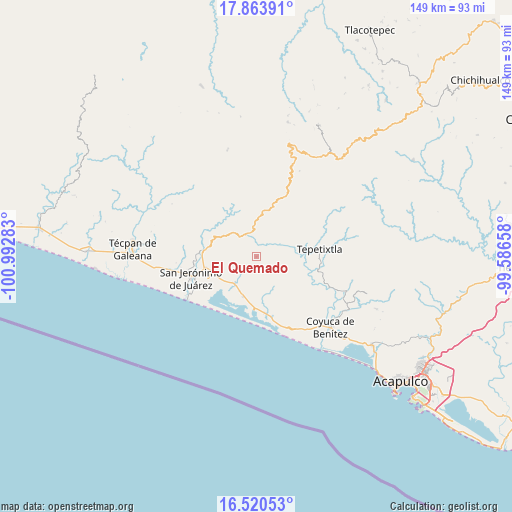
El Quemado GPS coordinates[2]
17° 11' 36.384" North, 100° 17' 22.92" West
| Map corner | latitude | longitude |
|---|---|---|
| Upper-left | 17.86391°, | -100.99283° |
| Center: | 17.19344°, | -100.2897° |
| Lower-right: | 16.52053°, | -99.58658° |
| Map W x H: | 149.4×149.4 km | = 92.8×92.8mi |
| max Lat: | 32.7° ⇑86.7% North |
| El Quemado: | 17.19344° |
| min Lat: | ⇓13.3% South 14.53588° |
| min Long | El Quemado | max Long |
| -117.105° | -100.2897° | -86.73105° |
| W 32.7%⇐ | ⇒67.3% E |
Elevation
Elevation of El Quemado is 583 m = 1913 ft, and this is 670.7 m = 2200 ft below average elevation for this country.
| Max E: |
3497 m = 11473 ft | 67% |
| Avg. | 1253.7 m = 4113 ft | |
| El Quemado | 583 m = 1913 ft | |
Min E: |
-1 m = -3 ft | 33% |
See also: Mexico elevation on elevation.city.
Geographical zone
El Quemado is located in North Torrid zone (between Equator and Tropic of Cancer). Distance of this Northern Tropic circle is 694.2 km =431.4 mi to North.| Distance of | km | miles | from El Quemado |
|---|---|---|---|
| North Pole | 8095.3 | 5030.2 | to North |
| Arctic Circle | 5489.4 | 3411 | to North |
| Tropic Cancer | 694.2 | 431.4 | to North |
| Equator | 1911.7 | 1187.9 | to South |


Nearby cities:
15 places around El Quemado: (largest is in red/bold)
• Alcholoa
13.5 km =8.4 mi,  249°
249°
• Atoyac de Álvarez
15.3 km =9.5 mi,  275°
275°
• Cacalutla
10 km =6.2 mi,  219°
219°
• Cayaco
16.4 km =10.2 mi,  172°
172°
• Colonia 2 de Diciembre de 1974
14.6 km =9.1 mi,  261°
261°
• Colonia Buenos Aires
13.9 km =8.6 mi, 252°
• Colonia Cuauhtémoc
11.2 km =7 mi,  206°
206°
• El Ciruelar
15 km =9.3 mi, 259°
• El Ticui
16.7 km =10.4 mi, 278°
• La Y Griega
15.6 km =9.7 mi, 258°
• Río Santiago
7.3 km =4.5 mi,  336°
336°
• San Andrés de la Cruz
10.2 km =6.3 mi,  313°
313°
• San Vicente de Jesús
9.6 km =6 mi,  12°
12°
• Santiago de la Unión
8.2 km =5.1 mi,  318°
318°
• Zacualpan
12.2 km =7.6 mi,  198°
198°
Sources, notices
• [Note1] Compared only with cities in Mexico existing in our database
• [Src1] Map data: © OpenStreetMap contributors (CC-BY-SA)
• [Src2] Other city data from geonames.org with taken over terms of usage.
• [Src3] Geographical zone / Annual Mean Temperature by Robert A. Rohde @ Wikipedia
